
Monitoring the behaviour of glaciers

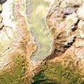 | |
Satellite image of Rhone glaciers
| |
As an example, we propose to monitor the behaviour of the Rhone glaciers in Central Switzerland.
As you can see from the map, this has been carried out several times in the past already.
| 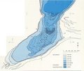 | | |
Behaviour of the Rhone glaciers from 1602 to 1969
|
This document shows two periods of time when the glacier advanced the most. One is around the year 1602 (followed by a warmer period) and the other is the year 1818.
The Rhone glacier has now started melting again! The most recent front line drawing dates back to 1973. It is therefore up to you to continue the research work and bring our knowledge up-to-date.
For this exercise you will need the maps of 1960, 1986 and 2009, as well as a satellite image.
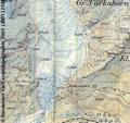 | |
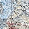
Rhone map of 1960
| |
If one wants to update maps frequently, the best way is to use satellite images. They are cheaper than large-scale air photographs and can be taken more often.
In fact, thanks to the high spatial resolution of satellite images and their easy availability, the information derived, although not fully replacing traditional cartography, can ensure constant monitoring of the Earth.
| 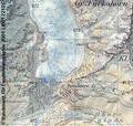 | | |
Rhone map of 1986
|
Let's do a little exercise that consists in comparing the satellite image to maps of three different editions. To do so, you can use the grid system applied to all our sample images as a reference on how to match them.
In practice, what you have to do is the following.
Transcribe the glacier outline shown by the satellite image and the maps onto the picture document with the historical glacier retreat. If you only have display software available, just bring all images to the same size. Then draw the outline on a transparent overlay superimposed on your PC screen.
 | |
Rhone map of 2009
| |
Once the updated front lines are added, try to assess the extent of the retreat and the melting process. Compared to past decades, is it going faster? You may wonder what has happened in the last years!
Search the Internet for latest satellite data, e.g. in Google Earth and compare them with the map of 2009!
Last update: 16 April 2013
| |
Glacial retreat in the Alps
| | • | Introduction (http://www.esa.int/SPECIALS/Eduspace_Global_EN/SEM8SQVPXPF_0.html) | |
Exercises
|
Resources
| | • | The Alps - Satellite images database (http://www.eduspace.esa.int/eduspace/alps/html/a1500500.asp) | | | • | Rhone glaciers (zip file) (http://esamultimedia.esa.int/docs/eduspace/Rhone_glacier.zip) | |
|
