Kathmandu - Now and then with optical images


 |  |
Kathmandu - Now and then
| |
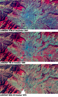
The false colour infrared Landsat images show the city of Kathmandu in different years.
The first image covers the recent dimensions of the city in a Landsat ETM satellite image. The second one was recorded by the Landsat TM satellite in 1989, and the third by Landsat MSS in 1976.
The strong reflection of chlorophyll in the near infrared band 4 leads to a reddish coloured vegetation in the image shown.
The urban areas are displayed in a dark blue colour range. The different extensions of the city are clearly visible, even at a glance.
Image - Technical information:
- Instrument: Landsat ETM, TM, MSS
- Date of Acquisition:
- 27 December 2001
- 31 October 1989
- 28 October 1976
- Path / Row: 141/41
- Colour combination: Red, Green, Blue
band 4, band 3, band 1
(654 for Landsat MSS)
- Scale: 1 : 200,000, 1 cm equals 2 km
(if printed unmodified in A4)
- Coordinates:
- NW Lat/Long: N 27.47 / E 85.10
- NE Lat/Long: N 27.47 / E 85.28
- SW Lat/Long: N 27.39 / E 85.28
- SE Lat/Long: N 27.39 / E 85.10
Goal: Analysis of the urban development of Kathmandu and seasonal changes.
Study the different colours of the images. Allocate the colours to the four main classes of land cover: urban area, forest, arable land and bare soil.
Compare and describe the three images in terms of the vegetation, which is shown in reddish colours, and find out the differences and the similarities. Explain the reasons for both of these.
Take a sheet of tracing paper and cover the 1976 image with it. Mark the corners of the image with cross-bars and draw the city limits of Kathmandu in 1976. Put the paper on top of the 1989 image using the cross-bars. Draw the city limits of Kathmandu in 1989. Repeat the same steps to draw the city limits of Kathmandu in 2001. Colour the areas marked with different colours and describe the expansion of the city.
To calculate the approximate surface changes, place the tracing paper on top of a sheet of graph paper and count the squares in each polygon, taking into account that one square mm equals 0.04 square km.
Based on the three images and your analysis of the urban expansion, discuss the possibilities of and limits to further expansion of the city in the Kathmandu Valley.
Last update: 16 April 2013

 |  | 
Kathmandu

| | • | Introduction (http://www.esa.int/SPECIALS/Eduspace_Global_EN/SEMF1QTTGOF_0.html) |  | | • | Background (http://www.esa.int/SPECIALS/Eduspace_Global_EN/SEMR3QTTGOF_0.html) |  | 
Exercises

| | • | Worksheet introduction (http://www.esa.int/SPECIALS/Eduspace_Global_EN/SEME7QTTGOF_0.html) |  | | • | Kathmandu Valley with radar image (http://www.esa.int/SPECIALS/Eduspace_Global_EN/SEMMBQTTGOF_0.html) |  | | • | Kathmandu Valley - General overview with optical images (http://www.esa.int/SPECIALS/Eduspace_Global_EN/SEMSQRTTGOF_0.html) |  | | • | Kathmandu - Now and then - Urban detection with optical images (http://www.esa.int/SPECIALS/Eduspace_Global_EN/SEM78STTGOF_0.html) |  | 
Links

| | • | References (http://www.esa.int/SPECIALS/Eduspace_Global_EN/SEMEJ4WPXPF_0.html) |  | | • | ESA's Proba website (http://www.esa.int/SPECIALS/Proba_web_site/index.html) |  | | • | The Landsat programme (http://landsat.gsfc.nasa.gov/) |  | | • | What is remote sensing? (http://www.esa.int/SPECIALS/Eduspace_EN/SEMF9R3Z2OF_0.html) |  | 
Eduspace - Software

| | • | LEOWorks 3 (http://esamultimedia.esa.int/multimedia/LEOWorks3.exe) |  | | • | ArcExplorer (http://esamultimedia.esa.int/multimedia/eduspace/ae2setup.zip) |  | 
Eduspace - Download

| | • | kathmandu.zip (http://esamultimedia.esa.int/multimedia/eduspace/kathmandu.zip) |  | | • | Technical information about Landsat bands (PDF) (http://esamultimedia.esa.int/docs/eduspace/Technical_data_LANDSAT_bands.pdf) |  | | • | Kathmandu_Proba.zip (http://esamultimedia.esa.int/docs/eduspace/Kathmandu_Proba_20040505.zip) |  |

|

