
Exercise 1 - Annapurna Region Overview

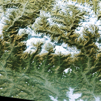 | |
Landsat TM satellite image of Annapurna region
| |
The Annapurna region covers the area around the Annapurna I mountain, and includes many spectacular peaks over 6,000 m in height. The Annapurna Conservation Area (ACA) was established in 1996. You can read more about the ACA in the Background section.
The Landsat TM satellite image of the Annapurna region was acquired on 15 December 2000. It shows the area 200 kilometres west of Kathmandu, from the border to China in the north, to the city of Pokhara in the south. In the centre of the image you can see the Annapurna Himal.
Many other geographical features are also visible in the image, such as the valley of the Kali Kandaki, stretching in a north-south direction, and Lake Phewa.
Take a map of Nepal in your Atlas or a map of the Annapurna region, and label the topographic view shown in the satellite image.
Name the valleys, the rivers and mountain ridges, the larger glaciers and the mountain peaks.
| 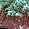 | | |
Near infrared false-colour image of the Annapurna region
|
In some parts it is rather hard to differentiate areas of vegetation from areas that are not covered by vegetation. In high altitude regions the shadows cast by the mountain range darken the Earth's surface in the near-natural colour image.
The infrared false-colour image of the Annapurna region, taken on 15 December 2000, allows us to determine the distribution of vegetation. All areas of vegetation are shown in a reddish colour, due to the strong reflective characteristics of chlorophyll in the near infrared band.
Look at the image and describe the distribution of vegetation.
Explain the reasons for the north-south alignment.
What does this mean for farming and population distribution?
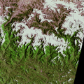 | |
Landsat MSS image of Annapurna region taken on 7 July 1979
| |
The Landsat MSS image of the same region was taken on 7 July 1979.
It shows the distribution of vegetation, snow, and ice during the summer months.
Compare the near-natural colour images of the Annapurna region with respect to the distribution of vegetation, snow, and ice. Identify and explain the differences.
Pay special attention to the distinction between snow and clouds in the Landsat MSS image. Describe the position of the clouds within the image. Is there any visible continuity?
Last update: 16 April 2013
| |
Annapurna Conservation Area
| | • | Introduction (http://www.esa.int/SPECIALS/Eduspace_Global_EN/SEM0V2XPXPF_0.html) | | | • | Background (http://www.esa.int/SPECIALS/Eduspace_Global_EN/SEMCV2XPXPF_0.html) | |
Exercises
| | • | Worksheet introduction (http://www.esa.int/SPECIALS/Eduspace_Global_EN/SEMHX2XPXPF_0.html) | | | • | Annapurna Circuit (http://www.esa.int/SPECIALS/Eduspace_Global_EN/SEMEZ2XPXPF_0.html) | | | • | Annapurna I Region (http://www.esa.int/SPECIALS/Eduspace_Global_EN/SEMG03XPXPF_0.html) | | | • | Pokhara Region (http://www.esa.int/SPECIALS/Eduspace_Global_EN/SEM823XPXPF_0.html) | | | • | Thorung La Region (http://www.esa.int/SPECIALS/Eduspace_Global_EN/SEMYC3XPXPF_0.html) | |
Eduspace - Software
| | • | LEOWorks 3 (http://esamultimedia.esa.int/multimedia/LEOWorks3.exe) | | | • | ArcExplorer (http://esamultimedia.esa.int/multimedia/eduspace/ae2setup.zip) | |
Eduspace - Download
| | • | annapurna.zip (http://esamultimedia.esa.int/multimedia/eduspace/annapurna.zip) | | | • | AnnapurnaGIS.zip (http://esamultimedia.esa.int/docs/eduspace/AnnapurnaGIS.zip) | | | • | subuint_annapurna.zip (http://esamultimedia.esa.int/docs/eduspace/subuint_annapurna.zip) | |
| 