|
The Islands of Kerguelen
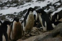
Besides penguins and seabirds, on these remote islands you may also encounter some scientists. There are around 300 islands in total, all of which are of volcanic origin. The highest point is Mont Ross, the glacier dome in the west of the main island, at 1 960 metres.
The plant species of the Kerguelen Islands is thought to have been brought from South America, rather than from comparatively nearer Africa. Can you guess why?
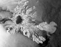
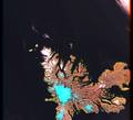
Let's briefly study the islands by comparing two satellite images provided by Envisat's ASAR radar and Landsat's visible infrared.
It is coloured because reflecting light in red, green, blue and infrared were captured separately and later combined to produce both a natural and artificial colour picture. The radar microwave instrument, on the other hand, only has one band. But the oblique viewing of the radar enhances the morphology drastically, and we can appreciate the landforms much better.
Try to map out the different parts of the island. The flat eastern part, the strangely 'curved' rock formations in the centre, and the rugged terrain with the glacier dome in the west. Why does it appear nearly black in the radar image?
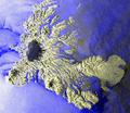
We combined both images to produce the ASAR-Kerguelen_stereo – image. Use red-green glasses to see the island in 3-D. If you invert the colours using the LEOWorks image processing software, the stereo effect is even stronger. Last update: 18 April 2013
| ||||||||||||||||||||||||||||||||||||||||||||||||||||||||||||||||||||||||||||||||||||||||||||||||||||||||||||||||||||||||||||||||||||||||||||||||||