
Leoworks Exercise: Optical properties of ice and snow

Introduction
With the help of the GoogleEarth file (location 3.1), get familiar with the archipelago of Svalbard (Spitsbergen). Below you will find a so-called true-colour combination of the visible Landsat channels over Brøggerhalvøya and Ny Ålesund. The little Ny Ålesund village and its airstrip are to the middle-left of the image. The big glacier system to the right is the Kronebreen. Kronebreen and its connected neighbours have an icefront into the sea.
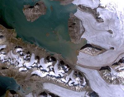 |
Landsat TM image of the Ny Ålesund area acquired on 23 July 2006
|
Brøggerhalvøya is a peninsula belonging to the Spitsbergen island in the Svalbard archipelago. Svalbard is situated in the Arctic Ocean at a Latitude of 74° to 81° N and a Longitude of 10° to 35° E, which is about halfway between mainland Norway and the geographic North Pole. This is far north of the Arctic circle, involving polar nights from late October to mid February, when the sun is continuously below the horizon, but also midnight sun from late April to late August. The islands cover an area of about 60 000 km², 60% of which is covered with glaciers.
The main settlement on Svalbard is Longyearbyen. It is situated on the island of Spitsbergen and has a population of about 2000 inhabitants. The main settlement on Brøggerhalvøya is Ny Ålesund, on the northern shore of the peninsula. It has a population of about 40 people, and is the third biggest settlement permanently inhabited.
Use the geographic web collection of GoogleEarth to find it. As there are no roads linking the settlements and different parts of the islands, transportation requires the use of snowscooters, planes and boats. Ny Ålesund mainly serves as a research station. Small glaciers near Ny Ålesundthat are very well investigated. The Kronebreen glacier is one of the largest and fastest-flowing of Svalbard. Close to its calving front into the sea, the ice flows up to 800 metres per year, that is several metres per day.
The climate on Svalbard is arctic but influenced by the Northatlantic current, which keeps the surrounding waters open and navigable to boats most parts of the year. The average temperature reaches around + 5° C during the summer and – 12° in the winter.
Last update: 16 April 2013
| |
Remote sensing of ice and snow
| | • | Remote sensing of ice and snow (http://www.esa.int/SPECIALS/Eduspace_Global_EN/SEMWD7TWLUG_0.html) | |
Background
| | • | Ice – a special substance (http://www.esa.int/SPECIALS/Eduspace_Global_EN/SEMHE7TWLUG_0.html) | | | • | Optical properties of ice and snow (http://www.esa.int/SPECIALS/Eduspace_Global_EN/SEMPJ7TWLUG_0.html) | | | • | Example (http://www.esa.int/SPECIALS/Eduspace_Global_EN/SEM0O7TWLUG_0.html) | |
Exercises
| | • | Purpose of the exercise (http://www.esa.int/SPECIALS/Eduspace_Global_EN/SEM9IDTWLUG_0.html) | | | • | Exercises (http://www.esa.int/SPECIALS/Eduspace_Global_EN/SEM7KDTWLUG_0.html) | |
Related link
| | • | GlobGlacier Project (http://globglacier.ch/docs/dvd/index.html) | |
Eduspace - Software
| | • | LEOWorks 3 (http://esamultimedia.esa.int/multimedia/LEOWorks3.exe) | |
Eduspace - Download
| | • | Landsat TM data (zip) (http://esamultimedia.esa.int/images/EduSpace/LEOWorks_material.zip) | | | • | GoogleEarth file (http://esamultimedia.esa.int/docs/eduspace/GoogleEarth_file eduspace_glacier.kmz) | |
|
