
Shillong

Sitting at 5000 feet, Shillong is nestled in the gentle hills of the Meghalaya Plateau, and legitimately holds the title 'Scotland of the East’. Generously carpeted by greenery and clad by mists, Shillong is at its wet best during the monsoon months of June to early October, when it receives about 60 per cent of its 3000 mm mean annual rainfall. If summers are wet and pleasantly warm, the chill during winter is bracing. There are few places in India as pleasant as the hill station of Shillong, which is precisely why more than a century ago the British made it their garrison during the 1860's. Originally meant for some 30,000 people, Shillong has quickly outgrown its capacity, and its greenery and open spaces have taken a toll. Its population has grown several folds to reach some 150,000 inhabitant. Vehicles clog its quaint streets, and the flow of traffic along its main roads frequently stutters along at slow speed as the numbers of vehicle owners has multiplied exponentially.
This is largely attributable to the local topography of hills hemming in the city on all sides, and severely constricting its horizontal expansion. This is why, in spite of being located in the most earthquake prone zone in India, it has of late started exhibiting vertical expansion of its built landscape and multistoried buildings are slowly emerging, as the city grapples with its residents.
 | |
Umiam Lake
| |
Shillong is bifurcated by the Umshyrpi and Umkhrah rivers that merge into the Umiam River. The latter has been dammed to form the Umiam Lake, from which the city derives its source of electricity.
|  | | |
Elephant Falls
|
The city attracts tourists from every corner of India, and boasts a number of waterfalls, of which the Elephant Falls is one of those much recommended to visit!
60 kilometers to the south of Shillong lies Cherrapunji, the wettest place in the world, which receives a staggering 11,000 mm annual rainfall. Cherrapunji has the world record of rainfall.
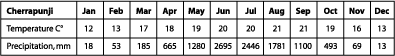 |
Climate data for Cherrapunji
|
The graph below shows the rainfall during the months of June to October and the NDVI of Sohra, the name by which Cherrapunji is locally known. Generally rainfall correlates quite well with NDVI, but this isn’t true in Sohra’s case - you could call it a case of being too much of a good thing!
What is NDVI? It is a vegetation index called Normalized Difference Vegetation Index that measures the health of vegetation. NDVI can be calculated using LEOWorks, which you can try out using satellite data with at least two bands.
 |
Rainfall (mm) and NDVI for the period of 1982 to 2003 in Cherrapuji
|
Last update: 16 April 2013
| |
Shillong and Guwahati
| | • | Introduction (http://www.esa.int/SPECIALS/Eduspace_Global_EN/SEMWVZ6UWJF_0.html) | | | • | Guwahati (http://www.esa.int/SPECIALS/Eduspace_Global_EN/SEMAYU3G6KF_0.html) | |
Exercises
| | • | Introduction (http://www.esa.int/SPECIALS/Eduspace_Global_EN/SEMIJZ3G6KF_0_ov.html) | | | • | Overview (http://www.esa.int/SPECIALS/Eduspace_Global_EN/SEMULZ3G6KF_0.html) | | | • | Shillong (http://www.esa.int/SPECIALS/Eduspace_Global_EN/SEMHNZ3G6KF_0.html) | | | • | Guwahati (http://www.esa.int/SPECIALS/Eduspace_Global_EN/SEMEQZ3G6KF_0.html) | |
Links
| | • | Useful links (http://www.esa.int/SPECIALS/Eduspace_Global_EN/SEMZEK0SAKF_0.html) | |
Eduspace - Software
| | • | LEOWorks 3 (http://esamultimedia.esa.int/multimedia/LEOWorks3.exe) | | | • | ArcExplorer (http://esamultimedia.esa.int/multimedia/eduspace/ae2setup.zip) | |
Eduspace - Download
| | • | Guwahati_1991.tif.zip (http://esamultimedia.esa.int/docs/eduspace/Guwahati_1991.tif.zip) | | | • | Guwahati_2002.tif.zip (http://esamultimedia.esa.int/docs/eduspace/Guwahati_2002.tif.zip) | | | • | Shillong_1999.tif.zip (http://esamultimedia.esa.int/docs/eduspace/Shillong_1999.tif.zip) | | | • | Shillong_2004.tif.zip (http://esamultimedia.esa.int/docs/eduspace/Shillong_2004.tif.zip) | |
|
