
Exercise 4 - Pokhara Region - Continued

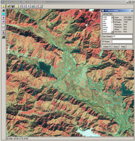 | |
Selection of training fields
| |
Supervised classification
The maximum likelihood classification is a supervised classification method based on sophisticated statistical algorithms. It integrates human knowledge using training fields that represent the different land cover classes.
Each land cover class has its own specific spectral fingerprint. At least one training field has to be defined for each type of land cover to be classified.
LEOWorks evaluates all these training fields and allocates each image element (pixel) to one of the given land cover classes.
Note: The more training fields you are able to select for a class and the more accurately you do it, the more accurate your result will be.
We are going to use the whole spectrum of Landsat bands.
To do this, open the images:
anapurna_landsat_2000_SE_band_1.tif
anapurna_landsat_2000_SE_band_2.tif
anapurna_landsat_2000_SE_band_3.tif
anapurna_landsat_2000_SE_band_4.tif
anapurna_landsat_2000_SE_band_5.tif
anapurna_landsat_2000_SE_band_7.tif
And select the training fields:
anapurna_landsat_2000_SE_band_432.tif
Select (activate) the image landsat_2000_SE_band_432.tif and choose Multivariate Analysis>Supervised Classification>Select Training Fields.
Select Draw Polygon from the toolbar.
Start with training fields for bodies of water. Draw a polygon within Lake Phewa and name the class 'water'. Draw another polygon within the South-Eastern lake and name the class 'water' again. Do the same with all other classes.
High Level Classes
- water
- city
- forest
- loose vegetation
- bare land
- soil
- shadows
- clouds
Choose Multivariate Analysis>Supervised Classification>Maximum Likelihood and select all images (except anapurna_landsat_2000_SE_band_432.tif).
Set the Threshold Value to '5%'.
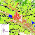 | |
Supervised classification of the Pokhara region
| |
Here again the colours of the classification results should be changed for easier interpretation.
Choose Image>Add Legend and check the combination of colours and class names.
Choose Edit LookUp Table and select the colour for the class 'forest'. Change the colour to a dark green. Change the other colours in the same way.
Save the classification as 'Pokhara_2000_supervised.tif' in your folder Annapurna.
Have a close look at the classified image and describe your impression.
How does the classified image fit with the optical images?
Which features are very well represented, and which are less well represented?
Why are there white (unclassified) parts within the image?
Compare the supervised and the unsupervised classification. Describe the advantages of the supervised classification. Which parts are better?
| 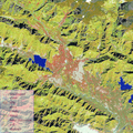 | | |
Overlayed images
|
The final step is to overlay the supervised classification on the infrared false-colour image so as to obtain a more realistic impression.
Choose Image>Transparent Overlay and select the images
Pokhara_2000_supervised.tif and
anapurna_landsat_2000_SE_band_423.tif
For example, select 50 for the Opacity and click OK. This parameter controls how much of the underlying image can be seen.
Last update: 18 April 2013
| |
Annapurna Conservation Area
| | • | Introduction (http://www.esa.int/SPECIALS/Eduspace_Global_EN/SEM0V2XPXPF_0.html) | | | • | Background (http://www.esa.int/SPECIALS/Eduspace_Global_EN/SEMCV2XPXPF_0.html) | |
Exercises
| | • | Worksheet introduction (http://www.esa.int/SPECIALS/Eduspace_Global_EN/SEMHX2XPXPF_0.html) | | | • | Annapurna Region Overview (http://www.esa.int/SPECIALS/Eduspace_Global_EN/SEMGY2XPXPF_0.html) | | | • | Annapurna Circuit (http://www.esa.int/SPECIALS/Eduspace_Global_EN/SEMEZ2XPXPF_0.html) | | | • | Annapurna I Region (http://www.esa.int/SPECIALS/Eduspace_Global_EN/SEMG03XPXPF_0.html) | | | • | Pokhara Region (http://www.esa.int/SPECIALS/Eduspace_Global_EN/SEM823XPXPF_0.html) | | | • | Thorung La Region (http://www.esa.int/SPECIALS/Eduspace_Global_EN/SEMYC3XPXPF_0.html) | |
Eduspace - Software
| | • | LEOWorks 3 (http://esamultimedia.esa.int/multimedia/LEOWorks3.exe) | | | • | ArcExplorer (http://esamultimedia.esa.int/multimedia/eduspace/ae2setup.zip) | |
Eduspace - Download
| | • | annapurna.zip (http://esamultimedia.esa.int/multimedia/eduspace/annapurna.zip) | | | • | AnnapurnaGIS.zip (http://esamultimedia.esa.int/docs/eduspace/AnnapurnaGIS.zip) | | | • | subuint_annapurna.zip (http://esamultimedia.esa.int/docs/eduspace/subuint_annapurna.zip) | |
| 