|
The Islands of Kerguelen - Continued
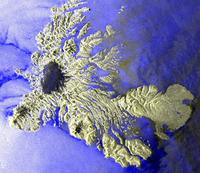
While orbiting the Earth, Envisat's radar always looks to the right. In these scenes, the westernly exposed slopes are brightly illuminated. This means that the satellite passed over the area coming from the south, hence on the night-side of the globe. In fact, it was 18:17 GMT, or 23:17 local time, when the satellite passed over the area. As mentioned already, radar does not need sunlight. It uses its own microwave resources to 'illuminate' the scene.
There was only local wind at that time of the night. And looking at the huge tongue-like feature on the sea just west of the glacier dome, we can identify the effect of the descent of cold and heavy air spreading out from the valleys into the sea – this is a typical nighttime valley wind in mountainous areas. We do not see the wind, but just the effect of it on the sea surface. When the icebreaker passed the island, our student took water samples at 49-23 South and 70-05 East and assessed the chlorophyll concentration. This allowed us to compare the measurement taken on the ground with the one made by the Envisat satellite at an altitude of 800 km. We do, however, have to keep in mind that onboard the ship only a few litres of seawater is analysed, while the satellite covers an area of around 1200 m x 1200 m for one measurement.
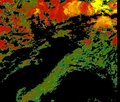
Look it up in the list of the 'resultats-chimie-chlorophyll' table file. Envisat flew over and measured the colours of the sea surface with its MERIS visible-infrared scanner.
There is more about how to measure chlorophyll concentration in the 'chlorophyll concentration exercice' you find on the right. Last update: 18 April 2013
| ||||||||||||||||||||||||||||||||||||||||||||||||||||||||||||||||||||||||||||||||||||||||||||||||||||||||||||||||||||||||||||||||||||||||||||||