|
Congo River Basin - Landsat data
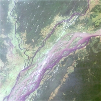
This image is a true-colour combination of the three visible channels, red, green, and blue (RGB), of a Landsat scene. The size of the pixels is 114 metres x 114 metres, and there are 512 x 512 pixels in the image. Consequently, the image covers an area of about 58.4 km x 58.4 km. But which part of the great Congo Basin's 4.1 million km² does the image show? And what is the name of the river which flows into the Congo River from northeast? Open the LEOWorks programme. If you have not downloaded the images of the Congo Basin yet, do so now. Open the image Congo_Landsat_Band_321_114m.tif. Choose File>Open. A dialog box will pop up. Choose the folder Congo and select the image Congo_Landsat_Band_321_114m.tif. Choose View>Cursor Position/Value. A pop-up window opens. Place the crosshair on the river junction and write down the latitude and the longitude. This is only possible because of the GeoTIFF format used for the data. GeoTIFFs embed geographic data as tags.
Using the information from the Cursor Position window, take a map of Central Africa and find the name of the rivers that flow into the larger Congo river.
The US satellite Landsat 7 ETM is NASA's 6th operational Earth observation satellite of this series (the launch of Landsat 6 failed in 1993). It is the latest in this series of Earth observation satellites dating back to 1972. The Landsat system therefore constitutes the longest continuous record of the Earth's surface. The main tasks of all Landsat satellites are environmental monitoring, disaster assessment, land use and regional planning, cartography, range management, and oil and mineral exploration. Its mode of operation has been continuously improved throughout the years. Today, the Landsat ETM features 8 channels, from visible light (channels 1,2,3) to near and middle infrared (channels 4,5,7) and thermal radiation (channel 6). The ground resolution is 15 metres for the panchromatic channel (8) and 30 metres for channels 1 to 5 and 7. The thermal channel 6 provides a resolution of 80 metres. The Landsat 7 satellite operates in a circular, sun-synchronous, near polar orbit. Learn more about the LANDSAT satellite program (NASA).
Download the PDF with the Technical data of Landsat bands table.
Open the LEOWorks programme. If you have not downloaded the images of the Congo River Basin yet, do so now.
Open the images. Choose File>Open. A dialogue box will pop up. Choose the folder Congo and select the first image Congo_Landsat_Band_1.tif. All the images need to be improved in brightness and contrast. Select (activate) the first image Congo_Landsat_Band_1.tif and choose Enhance>Histogram Equalization. The image will change. Convert all other images in the same way. Every single image reflects a part of the electromagnetic spectrum between 0.45 µm and 12.5 µm (visible light ranges from 0.45 µm to 0.7 µm). There are many different bands because different features of the Earth's surface can be seen in different parts of the electromagnetic spectrum, and the same features appear unequal in different parts of the spectrum. That means that all the imaged features or objects appear to to us in different colours when illuminated with light (including infrared). In order to distinguish the objects by their colour, we need an instrument capable of measuring in many bands, covering all the visible colours and the infrared sector.
Now have a look at the images and group them into two categories of similar appearance. Note the water and the northwestern vegetated area in particular. Compare the two groups with the table containing the different Landsat data bands. Are these two groups identifiable here, too? What is the special feature of congo_landsat_pan.tif? Last update: 16 April 2013
| ||||||||||||||||||||||||||||||||||||||||||||||||||||