 |
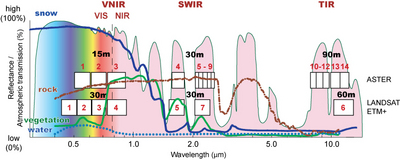
Propiedades ópticas del hielo y la nieve  Coloured lines: reflectance curves of snow, ice (first graphic), vegetation, water, rock (second graphic). Numbered boxes: wavelength range of the channels of the ASTER and the Landsat ETM+ (and TM) sensors with their spatial resolution (15m,..., 90m). Coloured area: atmospheric transmission; high values indicate that a high degree of solar radiation passes through the atmosphere, low values indicate that large parts of solar radiation are blocked by atmospheric gasses. VNIR: visible and near infrared; SWIR: shortwave infrared; TIR: thermal infrared; VIS: visible light; NIR: near infrared. Note that the reflectance curves for vegetation, water and rock are just examples. They can vary a lot with vegetation type and season, water turbidity and temperature, and rock type (here: granite).  Coloured lines: Reflectance curves of snow, vegetation, water, and rock. Numbered boxes: wavelength range of the channels of the ASTER and the Landsat ETM+ (and TM) sensors with their spatial resolution (15m,..., 90m). Coloured area: atmospheric transmission; high values indicate that a high degree of solar radiation passes through the atmosphere, low values indicate that large parts of solar radiation are blocked by atmospheric gasses. VNIR: visible and near infrared; SWIR: shortwave infrared; TIR: thermal infrared; VIS: visible light; NIR: near infrared. Note that the reflectance curves for vegetation, water and rock are just examples. They can vary a lot with vegetation type and season, water turbidity and temperature, and rock type (here: granite). |