Exercise 3: The importance of water in the Lake Chad area


 |  |
Fishing in Lake Chad
| |
More than 20 million people in the Chad region rely on the lake, either directly or indirectly. The water body of Lake Chad and its ample riverbanks are of extraordinary importance for the flora and fauna of the area. The lake provides a habitat for numerous animals, including about 120 fish species, and is a significant rest area for millions of migratory birds on their journey from Southern and Central Africa to Europe. The lake used to be an important crossing point of Western and Central African trade routes.
For residents of the region, the lake is losing more and more of its economic relevance due to its reduction in size. Consequently, many fishermen are stripped of their livelihood. Unfortunately, because there is not enough water for large-scale irrigation, these fishermen cannot even choose to get their livelihood from agriculture. Access to water for the fishermen is also hindered by the growth of grass, reed and papyrus.
Threats caused by the decline
Several conflicts have emerged as a consequence of the shrinking of Lake Chad. One of them, for instance, concerns the uncertainty regarding the rights to the remaining water of the countries bordering the lake. In addition, violence is increasing among the local population, especially those living around the lake.
Farmers and herders need the water in order to be able to cultivate their crops and nourish their livestock. In order to accomplish this, they are constantly diverting the water. However, the fishermen need the spare water to remain in the lake so that they can continue with their fishing activities. This is understandable, because it would mean an even further decrease in their already strained supply of fish.
Another point worth mentioning is the threat to animals in the lake area, which are also important sources of food for the local population.
Supervised classification
 |
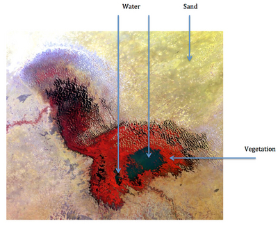
MERIS image with suggested locations for drawing training fields
|
Having applied and tested a few false colour combinations in the first LEOWorks exercise, decide which ones are best for classifying land cover in the Lake Chad area. Consider using one of the two contrast enhancement methods - histogram equalisation and interactive stretching.
What is the purpose of the training fields, and what could cause problems?
Create training fields for these three features and perform a Supervised Classification using the Maximum Likelihood algorithm with a threshold set to zero. You can then apply a post classification filter and improve the appearance of the classified image by changing the colours in the LUT editor in the Legend.
Compare the classified image with the MERIS image by viewing them side by side.
Get the "Report" from your classification and look up the surface of the water.
Compare it with your earlier measurement. What’s the difference?
Describe the classified image.
Can you pinpoint some problems in the image?
What can be done to improve the classification?
What are the consequences of the changes to Lake Chad for the people living on the shores of the lake?
Are there other lakes in the world with the same problems as Lake Chad?
Last update: 19 November 2013

 |  | 
The shrinking of Lake Chad

| | • | Introduction (http://www.esa.int/SPECIALS/Eduspace_Weather_EN/SEM4X9Z2OMH_0.html) |  | | • | Background (http://www.esa.int/SPECIALS/Eduspace_Weather_EN/SEM4Y9Z2OMH_0.html) |  | 
Exercises

| | • | Exercise 1: Visualisation of Lake Chad (http://www.esa.int/SPECIALS/Eduspace_Weather_EN/SEMRY9Z2OMH_0.html) |  | | • | Exercise 2: The shrinking of Lake Chad (http://www.esa.int/SPECIALS/Eduspace_Weather_EN/SEMJ9AZ2OMH_0.html) |  | 
Eduspace - Software

| | • | LEOWorks 4 (MacOS) (http://leoworks.asrc.ro/download/leoworks.app.zip) |  | | • | LEOWorks 4 (Linux) (http://leoworks.asrc.ro/download/leoworks.jar) |  | | • | LEOWorks 4 (Windows) (http://leoworks.asrc.ro/download/leoworks.exe) |  | 
Eduspace - Download

| | • | Landsat MSS_January 1973.tif (http://esamultimedia.esa.int/eduspace/2013/10/Landsat_MSS_LakeChad_January1973.tif) |  | | • | Landsat TM_December 1986.tif (http://esamultimedia.esa.int/eduspace/2013/10/Landsat_TM_LakeChad_December1986.tif) |  | | • | Envisat MERIS_January 2011.tif (http://esamultimedia.esa.int/eduspace/2013/10/Envisat_MERIS_LakeChad_January2011.tif) |  |

| 
