|
Windhoek - Namibia - Continued
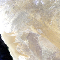
Let's go back the coastal plain. Explain the reason why a desert has been formed at this latitude. Compare the area with the western coast of Latin America, and with the east coasts of both continents with respect to the ocean currents.
What are the prevailing wind directions?
Ispect the well-developed dune field more closely. Measure some dunes from top to top (vertical distance between two 'lines'). What is the distance? Compare this measure with dunes you know, e.g. dunes along the coast. Is there a difference in the size? The pixel size of the image is 325 m. Geology - For a more detailed geological description, as well as a geological map, use this link.
Namibia - Link with more details on Namibia.
Windhoek, the capital of Namibia, looks very European with its colonial German architecture. Let's discover this particular town from aircraft and from space.
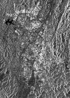
Now click on the Map Search button. The map will appear. Click the Satellite button to see the aerial photo. Now open the radar image named: 'Namibia_asar_windhoek_centre_town_040325'> Inspect both images, starting with the radar image:
Where is the city centre?
Point the different quarters and specially zoom in at the northern boundary of the city. Is there any sprawling by small huts into the country-side visible ? Look attentively at the border of the city. Do you notice any differences in the urban organisation? Describe it. Try to find the best residential area of the city. Now try to make the same observations using the aerial photo which has a much higher spatial resolution and is in colour. Now compare both images with respect to recognising and defining the city border, the housing density and building quality (large/small, high/low value, residential, etc). Which image represents the city border better? Which one is better for housing density recognition? On the ASAR image, some star-like features are visible. They are produced from extreme strong backscattering of the radar signal on roofs which are placed perpendicular to the radar illumination direction. Identify at least one such roof (e.g. near the airport). What is the direction of the radar illumination? (Tip: it is a nighttime satellite data acquisition. The satellite is travelling north and looking to the right side) What is the illumination direction of the aerial photo? In other words, in what period of the day was the aircraft flying? Make your own little study about the city of Windhoek. What is its economic and social importance for Namibia, and what is it for Africa? Judge the economic importance of the neighbouring countries, do a ranking and justify it.
Last update: 3 July 2013
| ||||||||||||||||||||||||||||||||||||||||||||||||||||||||||||||||||||||||||||||||||||||||