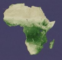
Click to see an animation of the seasonal change of the NDVI
The Normalized Difference Vegetation Index (NDVI) is used to show the amount of vegetation cover in remote sensing images. Vegetation gives a strong reflection in the 0.7 - 0.9 micrometre area (near infrared), whereas it gives a weak reflection in the 0.6 - 0.7 area (red) because of absorption by chlorophyll.
Because the spectral signature of vegetation is so characteristic, there are usually no problems in distinguishing between bare ground and green vegetation. As explained above, the difference between reflection in the visible and the near infrared ranges can be used to determine the extent of photosynthesis and plant growth. This can also be used to obtain information on the health status of the vegetation.
In the case of Landsat, channel4 is in the near infrared, and channel3 in the red spectral range, so the equation for the NDVI is:
(channel4 - channel3) / (channel4 + channel3)
In the animation, dark green indicates dense, healthy vegetation, whereas beige areas represent bare soil. Note the seasonal north-south movement of the vegetation belt. (Source of the animation: NASA/Goddard Space Flight Center Scientific Visualization Studio)
 | |
African climate
|
| • | Introduction (http://www.esa.int/SPECIALS/Eduspace_Weather_EN/SEM1C3KTYRF_0.html) |
|
| • | Background (http://www.esa.int/SPECIALS/Eduspace_Weather_EN/SEMLD3KTYRF_0.html) |
|
Exercises
|
| • | Introduction (http://www.esa.int/SPECIALS/Eduspace_Weather_EN/SEM5L3KTYRF_0.html) |
|
| • | Manual exercises (http://www.esa.int/SPECIALS/Eduspace_Weather_EN/SEMCM3KTYRF_0.html) |
|
| • | Exercises using LEOWorks (http://www.esa.int/SPECIALS/Eduspace_Weather_EN/SEM7Y3KTYRF_0.html) |
|
Links
|
| • | Meteosat images (http://www.eumetsat.int) |
|
| • | Actual weather
animation using
Meteosat (http://oiswww.eumetsat.org/IPPS/html/MSG/IMAGERY/IR108/BW/FULLDISC/) |
|
| • | Weather broadcast worldwide (http://weather.edition.cnn.com/weather/intl/forecast.jsp) |
|
| • | Climate system (http://www.espere.net/index.html) |
|
Eduspace - Software
|
| • | LEOWorks 3 (http://esamultimedia.esa.int/multimedia/LEOWorks3.exe) |
|
Eduspace - Download
|
| • | Africa - Meteosat visible channel (http://esamultimedia.esa.int/img/2013/11/Meteosat_VIS.zip) |
|
| • | Africa - Meteosat thermal infrared channel (http://esamultimedia.esa.int/img/2013/11/Meteosat_IR.zip) |
|
| • | Africa - Meteosat water vapour channel (http://esamultimedia.esa.int/img/2013/11/Meteosat_WV.zip) |
|