|
New Delhi, India - Continued
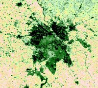
Two very different aspects of this megacity are shown on these images, although they carry the same message regarding the living quality. Open both images side by side in LEOWorks and compare them. On the MERIS image, the vegetation index is presented in a colour scale (black to light brown or low to high vegetation cover) outlining the city in green.
The black part represents very compact buildings, while light green stands for a 'garden quarter'. There is even a roundish light green and yellow area southwest of the centre. What is it?
It is an airport!
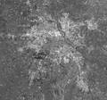
Inspect the image further. The radar image shows dense and high buildings in white. This corresponds to the black area in the MERIS image.
Is this true throughout the image? Measure the dimension of the city, its extension from north to south and from east to west. Use the 'Delhi_meris_040203_300m_boa_veg_pseudo_col' image. Pixel size is 300 m. Compare the distances with your city and with the capital of your country.
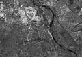
This is downtown Delhi seen by the imaging radar onboard Envisat. In the centre we can see a huge round square. This is Connaught Place. South of it we can recognise a dark, long, east-west feature with another huge round square at its eastern end. Raj Path and India Gate are the most important gathering places for parades and other national festivities. North of these two important places you can see the commercial centre and dense buildings, which are brightly imaged. The Yamuna River with several bridges is to the east.
Can you locate the high resolution radar image (12.5 m pixel size) on the lower resolution radar image (62.5 m pixel size)?
The river, the bright patches of dense buildings, and Raj Path can all be located easily on both images. Last update: 3 July 2013
| ||||||||||||||||||||||||||||||||||||||||||||||||||||||||||||||||||||||||||||||||||