Meteosat images


Five geostationary weather satellite systems have been placed in a constellation around the Equator. These include ESA’s Meteosat series, Japan’s GMS, India’s INSAT, and the USA’s GOES E and GOES W. These satellites produce new images of global weather conditions periodically. They do not, however, cover the Polar Regions.
Meteosat rotates on its own axis, which is parallel to the Earth’s axis. During each rotation it scans the Earth at a maximum resolution of 1 km from East to West. After each rotation the scanner mirror is tipped, and a new strip is scanned from South to North.
An image showing the entire Meteosat coverage is scanned in 15 minutes. The continuous stream of data is sent to a control centre in Darmstadt, Germany, where it is processed. The scan is performed in 12 bands, both in the visible and the infrared parts of the spectrum. In the Eduspace Interactive Meteosat project, five spectral bands are shown:
- VIS 0.6 µm (red band)
- VIS 0.8 µm (very near-infrared)
- NIR 1.6 µm (near-infrared)
- WV 6.2 µm (water vapour channel, mid-infrared)
- IR 10.8 µm (thermal-infrared)
 |
Visible channel image, VIS 0.6µm, with some ground observations from Interactive Meteosat
|
Visible channel images (VIS 0.6µm and VIS 0.8µm) display the amount of sunlight reflected back into space by clouds or the Earth's surface. Cloud-free water is typically dark, while clouds and snow appear bright.
The brightness of cloud-free land varies depending on the type of land cover. Thicker clouds have a higher reflectivity and appear brighter than thinner clouds.
It is difficult to distinguish between fog, low level clouds and high level clouds in a visible satellite image. To distinguish between these, thermal infrared satellite images are essential. In addition, composites of near-infrared and visible bands displayed together can differentiate between high level ice clouds and low level water clouds. Visible and near infrared images at night (when there is no solar radiation) appear totally black.
 |
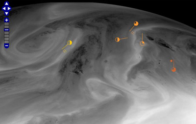
Water vapour channel image, WV 6.2 µm, including ground observations from Interactive Meteosat
|
Water vapour (WV 6.2 µm) images display infrared radiation levels, associated with atmospheric water vapour absorption. Water vapour images are useful for mapping regions of moist and dry air. Darker tones indicate drier air, while brighter tones depict more moisture in the air.
 |
Thermal infrared channel image, IR 10.8, including ground observations from Interactive Meteosat
|
In the thermal infrared channel (IR 10.8µm), cold surfaces are visualised in bright tones and warm surfaces appear dark. Although clouds may appear the same in thermal infrared and visible channels, there are significant differences.
In thermal infrared, the brightest clouds are the coldest, and consequently the highest in the atmosphere, as temperature decreases with height above the Earth's surface in the troposphere. The darker the cloud formation, the lower it is above the Earth’s surface. For IR 10.8 µm images it can be difficult to distinguish between low-lying clouds and cloudless areas, because the temperature difference between the cloud and a wet surface on the Earth can be very little.
 |
Colour composite RGB image with some ground observations from Interactive Meteosat
|
The colour composite RGB image makes use of three channels: VIS0.6, VIS 0.8 and NIR1.6. In this colour scheme, vegetation appears greenish because of its much larger reflectance in the VIS 0.8 channel (displayed in Green) than in either the NIR1.6 channel (displayed in Red) or VIS0.6 channel (displayed in Blue). Water clouds with small droplets have large reflectance in all three channels, and hence appear whitish, while snow and ice clouds appear cyan because ice strongly absorbs in NIR1.6 (less signal in the Red colour). Bare ground appears brown because of the larger reflectance in the NIR1.6 than in the VIS0.6, and the ocean appears black because of the low reflectance in all three channels (see also www.eumetsat.int).
Last update: 30 October 2013

 |  | 
Interactive Meteosat

| | • | Interactive Meteosat (http://www.esa.int/SPECIALS/Eduspace_Weather_EN/SEMTOGJ37SG_0.html) |  | 
Background

| | • | Europe’s climate and weather (http://www.esa.int/SPECIALS/Eduspace_Weather_EN/SEM9RGJ37SG_0.html) |  | | • | General description of the weather (http://www.esa.int/SPECIALS/Eduspace_Weather_EN/SEM4EHJ37SG_0.html) |  | 
Exercises

| | • | Worksheet Introduction (http://www.esa.int/SPECIALS/Eduspace_Weather_EN/SEM0NIJ37SG_0.html) |  | | • | Exercise 1: Inspect the Meteosat images (http://www.esa.int/SPECIALS/Eduspace_Weather_EN/SEMKPIJ37SG_0.html) |  | | • | Exercise 2: Find weather boundaries (http://www.esa.int/SPECIALS/Eduspace_Weather_EN/SEMSPKJ37SG_0.html) |  | | • | Exercise 3: Find low pressure systems (http://www.esa.int/SPECIALS/Eduspace_Weather_EN/SEMJQKJ37SG_0.html) |  | | • | Exercise 4: My weather forecast (http://www.esa.int/SPECIALS/Eduspace_Weather_EN/SEM1SKJ37SG_0.html) |  | 
Related links

| | • | Interactive Meteosat online application (http://www.asrc.ro/imeteosat_beta/geostationary_view.php) |  | | • | Interactive Meteosat User Manual (http://esamultimedia.esa.int/docs/eduspace/InteractiveMeteosatUserManual_EN.pdf) |  | 
Additional information

| | • | Wind speed table (http://esamultimedia.esa.int/docs/eduspace/windspeedtable.pdf) |  | | • | Useful weather links (http://www.esa.int/SPECIALS/Eduspace_Weather_EN/SEMNDNJ37SG_0.html) |  |

|

