Download de klimaatdiagrammen (pdf) en print ze uit
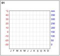
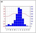
Klimaatdiagrammen beschrijven het overheersende klimaat op een goed gedefinieerde positie. Ze laten de gemiddelde neerslag en de temperatuur in de loop van het jaar zien.
Op die manier is het mogelijk om de diagrammen te koppelen aan de klimaatzones en de plek waar de gegevens zijn verkregen. Print het pdf-bestand met de klimaatdiagrammen uit en vul de temperatuurslijn en de neerslagstaven in (of gebruik de kant-en-klare diagrammen hieronder).
Koppel de diagrammen vervolgens aan elk van de gegeven plekken waar gegevens zijn verkregen.
Download de temperatuursdiagrammen (pdf) en print ze uit.
 | |
Himalaya
|
| • | Introductie (http://www.esa.int/SPECIALS/Eduspace_Weather_NL/SEMJ5XISDNG_0.html) |
|
| • | Achtergrond (http://www.esa.int/SPECIALS/Eduspace_Weather_NL/SEMTAXISDNG_0.html) |
|
Oefeningen
|
| • | Introductie (http://www.esa.int/SPECIALS/Eduspace_Weather_NL/SEMJSXISDNG_0.html) |
|
| • | Handmatige oefeningen (http://www.esa.int/SPECIALS/Eduspace_Weather_NL/SEMQUXISDNG_0.html) |
|
| • | Bestuderen van waterdamp in de atmosfeer (http://www.esa.int/SPECIALS/Eduspace_Weather_NL/SEM6C3JSDNG_0.html) |
|
| • | De zomermoesson en de overstromingen die daarbij horen (http://www.esa.int/SPECIALS/Eduspace_Weather_NL/SEM9F3JSDNG_0.html) |
|
Links
|
| • | Meteosat images (http://www.eumetsat.int) |
|
| • | Weather broadcast worldwide (http://weather.edition.cnn.com/weather/intl/forecast.jsp) |
|
| • | Climate system (http://www.espere.net/index.html) |
|
| • | CARE (http://www.careinternational.org.uk/) |
|
| • | DLR - Basemapping
of Dhaka (http://www.zki.caf.dlr.de/applications/2004/bangladesh/bangladesh_flood_2004_en.html) |
|
Eduspace - Software
|
| • | LEOWorks 3 (http://esamultimedia.esa.int/multimedia/LEOWorks3.exe) |
|
| • | ArcExplorer (http://esamultimedia.esa.int/multimedia/eduspace/ae2setup.zip) |
|
Eduspace - Download
|
| • | Climate zones (PDF) (http://esamultimedia.esa.int/docs/eduspace/climatezones.pdf) |
|
| • | Climate diagrams (PDF) (http://esamultimedia.esa.int/docs/eduspace/Diagramm.pdf) |
|
| • | Temperature and precipitation diagrams (PDF) (http://esamultimedia.esa.int/docs/eduspace/himalaya_climate_temperature.pdf) |
|
| • | Ready-made diagrams (PDF) (http://esamultimedia.esa.int/docs/eduspace/Diagramm_fill.pdf) |
|
| • | Himalayas water vapour images (ZIP) (http://esamultimedia.esa.int/docs/eduspace/MERIS_WV_2003.zip) |
|
| • | SPOT XS images of Bangladesh (ZIP) (http://esamultimedia.esa.int/docs/eduspace/flood88.zip) |
|
| • | Landsat images of Bangladesh (ZIP) (http://esamultimedia.esa.int/docs/eduspace/ganges1989_2000.zip) |
|
| • | Shape files for Bangladesh (ZIP) (http://esamultimedia.esa.int/docs/eduspace/shapes_bangladesh.zip) |
|
| • | Map of climate zones (http://www.esa.int/images/climatemap,0.jpg) |
|