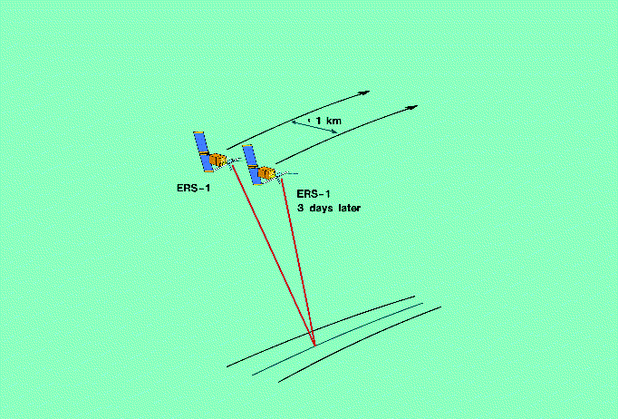
Figure 1. During repeat orbits, ERS-1 returns to provide almost identical sensor positions after intervals of 3 or 35 days, thereby acquiring SAR images that can be analysed interferometrically

The European Remote Sensing Satellite ERS-1, launched by ESA in 1991, carries an Active Microwave Instrument (AMI). During several phases of its operations, ERS-1 has been operated in almost exact repeat orbits with periods of 3 and 35 days. The data acquired during these repeat orbits can be used to perform repeat-pass SAR interferometry, as illustrated in Figure 1. The excellence of ERS-1's orbit and attitude control system and the high reliability of its SAR system result in excellent interferograms.
Figure 1. During repeat orbits, ERS-1 returns to provide almost identical sensor positions after intervals of 3 or 35 days, thereby acquiring SAR images that can be analysed interferometrically
Radar remote sensing has made significant advances in recent years, exemplified by the revolutionary new applications developed using Synthetic Aperture Radar (SAR) interferometry. Interferometric processing of SAR data combines images from two space-craft passes to derive precise measurements of the difference in path lengths to the two sensor positions.
Thanks mainly to the high quality and extensive coverage of the ERS-1 SAR data, the development and application of repeat-pass SAR interferometry has become a prime research activity within the radar remote- sensing community. Two of the major applications, the derivation of height maps and of differential displacement maps, are based on the geometric information contained in the so-called 'interferometric phase' (see below). Much research is being performed to further refine the image-processing steps required for the estimation of this interferometric phase in order to optimise these two types of maps.
The quality of the products is characterised by the 'interferometric correlation', which is a measure of the variance of the interferometric phase estimate. It decreases with increasing system noise, volume scattering, and temporal changes. Consequently, the interferometric correlation itself contains significant thematic information that can be useful for several other applications, which are also discussed below.
In SAR imaging, the backscattering signal from a particular area or object - known as a 'resolution cell' - is the coherent superposition of the backscattering from the many individual scatterers within that cell, resulting in a random phase and the typical image phenomenon known as 'speckle'. Until recently, only the magnitude of the SAR signal, but not the phase, was interpreted. Now, with the advent of SAR interferometry, the phase data is proving to be a valuable additional source of information. For two SAR images acquired with almost identical antenna positions, the scatter geometries are almost identical and therefore the speckle patterns of the two images are not independent. The 'interferometric phase' - i.e. the phase difference between the two images - is a measure of the difference in path lengths to the sensor, permitting derivation of the three- dimensional position of the scattering element.
In the case of ERS-1, such data has been acquired during repeat orbits at times differing by multiples of either 3 or 35 days. The interferometric phase derived from these data can therefore be used to produce height maps for the regions with repeat ERS coverage, as illustrated in Figure 2.
Figure 2 shows an example of an interferogram centred on Bern, Switzerland, produced from data collected by ERS-1 on 24 and 27 November 1991 (3-day repeat cycle). The interferometric phase is displayed using the colour scale (cyclical) indicated below the image. The interferometric baseline component perpendicular to the line of sight is 58 m for this image pair, and therefore one phase cycle corresponds to an elevation difference of approximately 160 m. The brightness of the image is a measure of the interferometric correlation.
The interferometric correlation depends on the radar-system parameters of wavelength, signal-to-noise ratio, range resolution, and number of independent observations, and on the geometric parameters of interferometric baseline and incidence angle. As long as we restrict our investigation to data from one instrument, identical instrument parameters can be used. Common spectral band filtering of the SAR image pair before computation of the interferogram ensures that most of the interferometric decorrelation introduced by the baseline geometry is eliminated. The remaining sources for the observed decorrelation are volume scattering and temporal change, i.e. changes occurring between the two ERS-1 data acquisitions. In practice, therefore, repeat-pass SAR interferometry is very sensitive to temporal change.
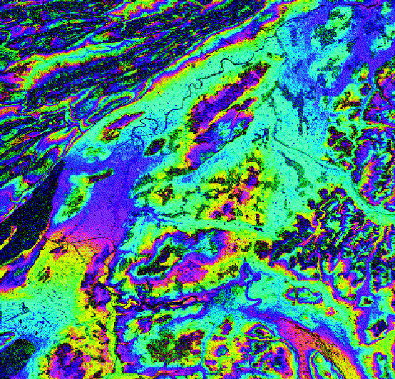
Figure 2. Repeat-pass SAR interferogram computed from ERS-1 SAR data acquired on 24
and 27 November 1991 over Bern, Switzerland. The interferometric phase is colour-coded as indicated below the image. One 2p phase
cycle corresponds to an elevation difference of 160 m. The image brightness is proportional to the interferometric correlation
In these times of increasing environmental problems, reflected by for example increasing deforestation, possible climatic changes, and intense use of forests as a source of both energy and construction material, there is a great need for forest mapping and monitoring for both ecological and economic reasons. Satellite remote sensing provides a means of gathering such information regularly on a regional/global scale, even for remote areas that are difficult to access by any other means. Interferometric forest mapping and monitoring from space can therefore play an important role.
Intensive research efforts have been conducted mainly with optical and microwave remote-sensing instruments. The main disadvantage of optical sensors is that cloud-free conditions are required, compared to the all-weather capability of microwave sensors. This turns out to be very limiting for many regions, especially in the tropical, sub-polar and polar zones. Change monitoring is even more problematic, because the data must be acquired at regular time intervals in order to be meaningful.
Thanks to ESA's ERS-1 mission and planned followup programmes ERS-2 and Envisat, Japan's JERS-1, and Canada's planned Radarsat, SAR data will be available to us for at least the next fifteen years. However, the interpretation of individual SAR images is not as straightforward as with optical images because of the complex interaction between the radiated electromagnetic field and the target. Forest mapping is very difficult because of the image noise ('speckle') noted above, because the signatures of the various land categories differ by only small amounts and sometimes overlap, and also because of topographic effects. However, SAR interferometry makes forest mapping with ERS-1 virtually straightforward.
The region shown in Figure 2 covers agricultural, urban and forested areas, as well as a number of lakes. In late November, most agricultural fields are bare or only sparsely vegetated and the deciduous trees (mainly beech, oak and maple) are without leaves. A number of test areas were selected within this ERS-1 scene and in-situ data were collected via site visits and land-use inventories. Forest composition and structure, tree heights, and the local topography were measured. Differences were observed between the deciduous (more than 80% of the trees deciduous), coniferous (more than 80% of the trees coniferous), and mixed forest stands. For selected areas, corresponding to forest stands, agricultural fields, residential areas, and open water (lakes and rivers), the interferometric correlation and average back- scatter intensities were extracted.
Figure 3 shows the backscatter intensity measured on 24 November as a function of the interferometric correlation. Only back-scatter intensity changes larger than 0.5 dB between 24 and 27 November are indicated by vertical lines. Water surfaces, forest and areas that changed between these two dates show low interferometric correlations. High correlation is observed over agricultural and urban areas. The highest backscatter intensities, together with a high spatial variability, are observed over urban areas.
The ranges of backscatter intensities observed over forests and agricultural fields overlap strongly. This explains the difficulty encountered in distinguishing between these two classes based exclusively on the backscattering intensity at C-band. Except during windy conditions, the backscatter intensity over water is very low. Due to the sensitivity to wind speed and direction, a high temporal variability in backscatter intensity is observed. Temporal change introduced by mechanical cultivation (ploughing, harvesting, etc.) causes almost complete interferometric decorrelation. Such change occurs at a specific moment in time, and the same fields may show high interferometric correlation in interferogram pairs preceding or following that event. The signatures for the different land-use categories cluster well. The interferometric correlation, together with the backscatter intensity and the backscatter intensity change, is therefore a very promising tool for the classification of the land-surface classes indicated. It becomes obvious from the extracted signatures that the backscatter intensity and the interferometric correlation are relatively independent quantities containing complementary thematic information.
Figure 4 shows forest signatures in greater detail. The interferometric correlation is higher for deciduous than for coniferous forest stands. Despite the winter season, the backscatter intensity of the leafless deciduous trees does not serve as a reliable forest type discriminator. As one would expect, the values for the mixed forest stands lie between those for deciduous and coniferous stands. Detailed studies of the interferometric correlation over mixed forest stands show that areas of low correlation usually coincide with regions with a high density of coniferous trees. Fruit orchards and open forest stands have higher interferometric correlation values.
To improve accessibility to the information content of the interferometric signatures, the interferometric correlation, the backscatter intensity from one of the passes, and the backscatter intensity change can be displayed using the three channels of an RGB-image, as shown in Figure 5. The red-value is proportional to the interferometric correlation, the green-value to the square root of the backscatter intensity, and the blue-value to the backscatter intensity change in decibels (dB). Figure 5 again shows the Bern test site, covering an area approximately 45 km by 45 km. With the colour coding chosen, forests appear dark green and open water surfaces dark blue, which simplifies the identification of those important categories. Urban areas appear bright green or yellow. There are often strong individual scatterers within these urban areas. Bare and sparsely vegetated areas appear orange or yellow. Owing to change occurring between the two data acquisitions, a number of agricultural fields appear green-blue in the red-yellow of the surrounding unchanged plots. The colours for the different land categories are listed and explained in Table 1.
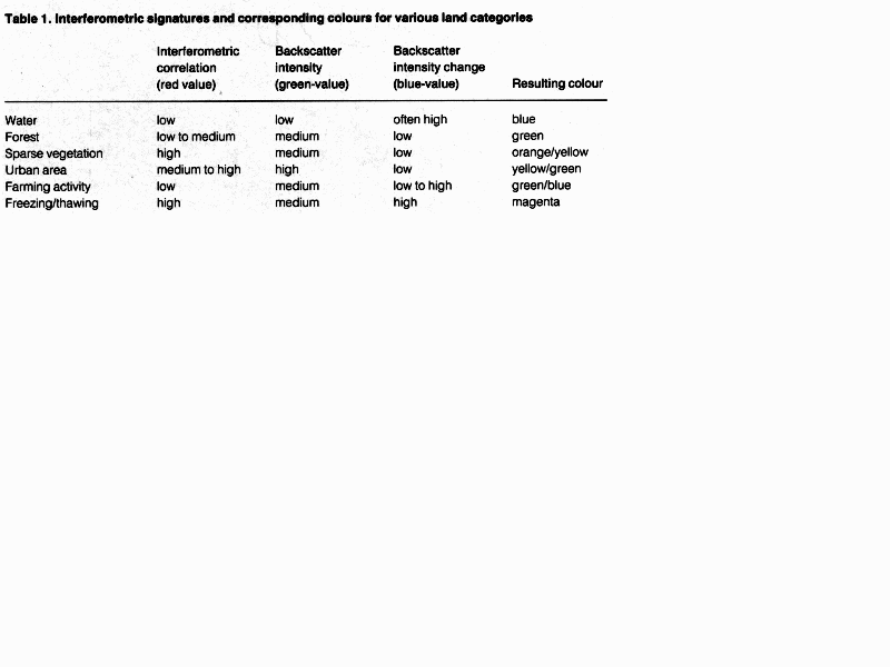
Table 1
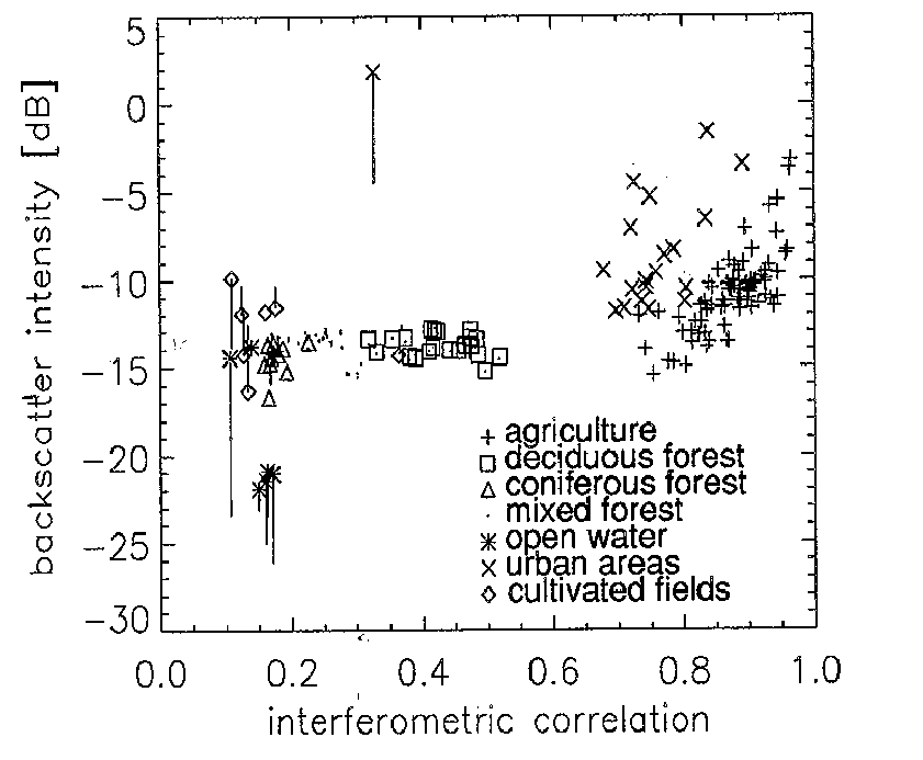
Figure 3. Average backscatter intensities plotted as a function of the interferometric correlation
for selected test areas within the ERS-1 SAR scene over Bern. Vertical bars indicate backscatter intensity changes of more than
0.5dB between 24 and 27 November 1991
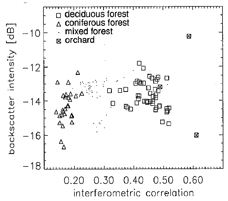
Figure 4. Average backscatter intensities plotted as a function of the interferometric correlation
for selected forest stands within the ERS-1 SAR scene over Bern
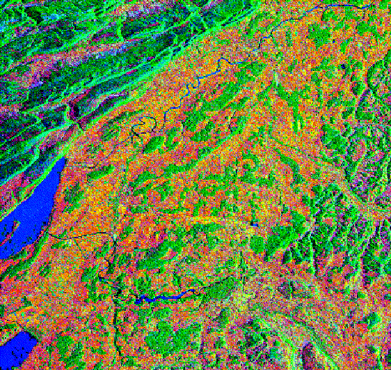
Figure 5. Interferometric signatures - red = interferometric correlation; green = backscatter intensity on 24 November; blue = backscatter
intensity change between 24 and 27 November - derived from an ERS-1 SAR image pair over Bern, Switzerland. Water (blue), forest
(green), sparse vegetation (orange/yellow), and urban areas (yellow/ green), as well as certain farming activities (green/blue) and frost
(magenta), can be clearly identified (see also Table 1)
The Bern test-site data just discussed were acquired in late November 1991. During the night of 26/27 November, parts of the surface within the test site froze. When the SAR image was acquired at 11.20 on the morning of 27 November, certain areas were still frozen while other parts in direct sunshine had already thawed. The frozen areas are on the shady northwest-facing slopes of hills. Such freeze/thaw cycles are common in this area during cloud-free periods in winter.
Freezing causes a reduction in the backscatter intensity of approximately 3 dB. On 24 November, the entire scene was unfrozen and so the areas frozen on 27 November can be clearly identified via a strong backscatter intensity change. Freezing changes the permittivity without significantly changing the surface geometry and so the interferometric correlation remains high despite the strong backscatter intensity change.
Consequently, areas frozen during the ERS-1 data acquisition on 27 November appear in magenta in Figure 5, i.e. areas northwest of the Belpberg hill (south of the city of Bern), as well as in the hilly parts of the Emmental (right of image centre) and the Jura mountains (upper left corner of image). The entire interpretation was first done based exclusively on the SAR interferometric signatures; only later were these hypotheses validated with meteorological data. ERS-1 data acquired on the same dates at night over the northeastern part of the Bern test site, i.e. the Emmental, further confirms the freeze/thaw hypothesis and allows the extent of the nocturnal freezing to be mapped.
As we have already seen, ERS-1 repeat-pass SAR interferometry can be used to detect and map various types of change occurring between the acquisitions of an image pair. Series of SAR images can therefore be used, for instance, to monitor farming activities.
To demonstrate the feasibility of SAR interferometric farmland monitoring, ERS-1 data acquired on 14, 17, 20 and 29 March over an agricultural test site west of Bonn, in Germany, were selected. It includes the rural area of the Zuelpicher Boerde, the mainly forested Ville region, the cities of Bonn, Euskirchen, Dueren, Kerpen, Huerth, Bruehl and Wesseling, a section of the river Rhine, a number of small lakes, and the open-pit lignite mines of Frechen and Ville.
In March, most agricultural fields are bare or only sparsely covered with grass or crops such as winter cereals. Only in the middle of that month do the farmers start cultivating their fields. The deciduous trees are still leafless. Figure 6 shows interferometric signatures derived from the 14 and 17 March image pair, which allow recognition of the different land-use categories and highlight changes that have occurred during the intervening three days. By applying the same approach to all possible image-pair combinations, relatively detailed monitoring of change throughout the second half of March 1992 becomes possible.
Figure 7 is a multi-temporal image of the interferometric correlation of the 14 and 17 March (red color), 17 and 20 March (green), and 17 and 29 March (blue) image pairs. The corresponding baseline components perpendicular to the line of sight are 420 m, 507 m and 551 m, respectively. The scene is an agricultural area west of Bonn and it highlights changes in individual fields during this period with different colours, indicating the time interval when the change occurred. Individual fields that were mechanically cultivated between 14 and 17 March, for instance, appear turquoise due to the low correlation for that image pair and the high correlations for the other two pairs. Change between 17 and 20 March appears in red due to the low correlation between the 17 and 20 March, and 17 and 29 March pairs, and so on. Help with the interpretation of the different colours is provided by Table 2.
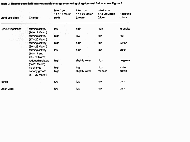
Table 2
It is worth noting that only a few fields lost correlation between 14 and 17 March. More fields lost correlation between 17 and 20 March, probably as a result of mechanical cultivation. A second, partial decorrelation observed in the data set is thought to be due to small geometric changes, perhaps caused by erosion and vegetation growth. The partial decorrelation resulting from vegetational growth and a relatively small decorrelation in the 17 and 20 March pair due to the lower soil moisture on 20 March can be identified by their brown and magenta colours, respectively, in Figure 7.
For comparison purposes, Figure 8 shows a multi-temporal image of the backscatter intensity. Clearly, the information content of repeat-pass SAR interferometric signatures is significantly higher than that of the identical multi-temporal SAR data if only the backscatter intensity is interpreted. On the other hand, the multi- temporal image of the backscatter intensity adds information to the interferometric correlation. The overall bluish-magenta tone over agricultural areas shows that the soil moisture decreased from 14 March (green colour) to 17 March (red) and then increased again from 17 March to 29 March (blue). The green colour of open-water surfaces indicates that the backscattering over water was highest on 14 March, probably due to the rougher water surface caused by wind or rain. Owing to the almost identical image geometry for the three data sets, temporal changes can be easily detected, even without prior normalisation of the backscattering intensity.
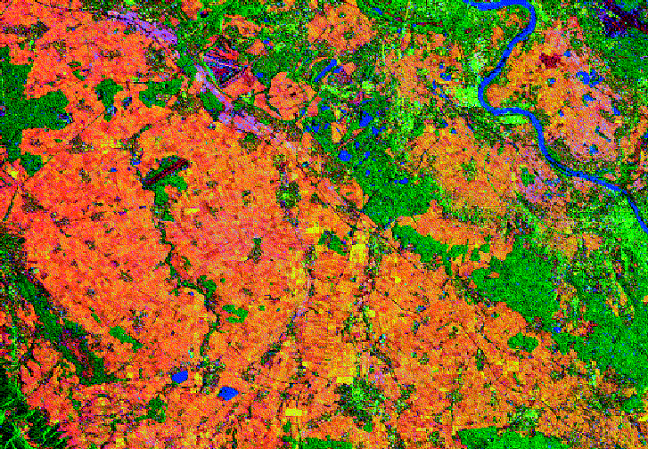
Figure 6. Interferometric signatures - red = interferometric correlation; green = backscatter
intensity on 17 March; blue = backscatter intensity change between 14 and 17 March - derived from an ERS-1 SAR image pair acquired
west of Bonn, Germany. Water (blue), forest (green), sparse vegetation (orange/yellow), and urban areas (yellow/green), as well as
certain farming activities (green/blue) and changing soil moisture (magenta), can easily be identified (see also Table 1)
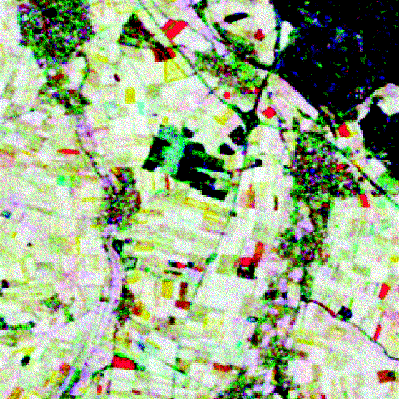
Figure 7. Multi-temporal image of the interferometric correlation, computed from four ERS-1
SAR images acquired on 14,17, 20 and 29 March. The interferometric correlations of the 14 and 17 March (red), 17 and 20 March
(green), and 17 and 29 March (blue) pairs are combined in this colour composite. Change occurring between the two data acquisitions
of an image pair reduces the corresponding interferometric correlation. This colour composite therefore allows farming activities and crop
growth during the second half of March 1992 to be monitored easily and reliably
(see also Table 2)
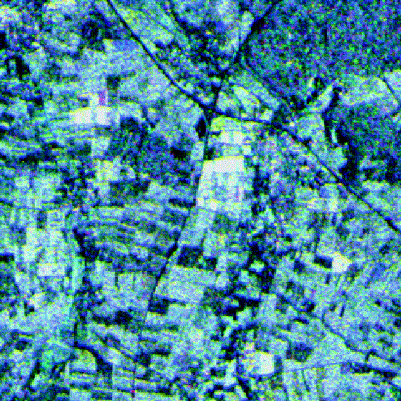
Figure 8. Multi-temporal image of the ERS-1 SAR backscatter intensity on 14 (green), 17 (red),
and 29 (blue) March. Interferometric processing was used to precisely co-register the three SAR images. With the exception of the open-water surfaces, the colour composite appears quite grey. Over agricultural fields, the values on 14 and 29 March are higher than on 17
March due to higher soil moisture. The relatively small backscatter intensity differences do not correlate with the individual field
boundaries. The green colour of the river Rhine and a number of small lakes results from the low backscattering on 17 March caused
by the low wind speed
The high potential of ERS-1 repeat-pass SAR interferometry for land applications has been demonstrated, focussing on the interpretation of the interferometric correlation in combination with the backscatter intensity and the backscatter intensity change between the two passes used for the interferogram. The interferometric correlation depends on the amount of volume scattering and temporal change, and therefore provides excellent information for land-use classification applications.
Given the weather-independence of the SAR system and the repetitive global coverage provided by ERS- type spacecraft, the approach described here constitutes a very powerful tool for land-use mapping and monitoring. With the continued availability of appropriate data from ERS-1 and its follow-up satellites ERS-2 and Envisat throughout the next decade, SAR interferometry is expected to contribute significantly to forestry and land-use applications and related global-change studies. The proposed ERS-1/ERS-2 tandem mission scenario with the two satellites operated in the same orbit 1 or 8 days apart would be of special interest for scientific research and applications purposes, since it would permit global coverage with interferometric image pairs at a high repetition rate.
The work reported here was supported bu ESA's European Space Research and Technology Centre (ESTEC) and the European Union's Joint Research Centre (JRC).


 ESA Bulletin Nr. 81.