
Two Different Views of the Landscape around Izmir, Turkey
The routine exploitation of the wealth of data delivered by ESA's ERS-1 and ERS-2 satellites, launched in 1991 and 1995 respectively, continues to proceed in a highly satisfactory manner. The SAR imagery in particular has been the target of much attention from the professional remote-sensing community, as well as the general public.
The multi-temporal image-interpretation concept, based on the combined use of images taken on different dates during the year to highlight changes that have taken place by displaying them in different colour tones, is proving a highly successful application. These multi-season images allow, for example, the identification of specific crops, because the nature of the vegetational growth during a particular season is very crop-specific. Another technique relies on combining images taken during the same season, but in different years. In this multi-year imagery, the landscape changes not only due to crop rotation, but also due to new construction, etc., which is easily detectable.
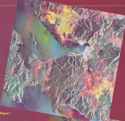
The image in Figure 1 is composed of three ERS SAR data sets acquired during the same year, but in different seasons. By assigning each data set an individual colour (red to data from 6 May 1995; green to data from 19 August 1995; blue to data from 6 January 1996), seasonal variations (e.g. in the vegetation) appear in various colour tones, whilst black and white represent areas without change.
The area imaged here includes the Gulf of Izmir to the top left. The white areas in the innermost part of the gulf delineate the city of Izmir itself.
The sea colours merely reflect wind conditions during the data acquisitions, with winds roughening the sea's surface causing increased radar backscatter. The prevalence of blue and magenta over the other colours is evidence that a strong wind was blowing from the north on 6 January, whereas the winds were rather weak on the other two acquisition days.
On the land, different kinds of vegetation cover and the presence of woods on hills and mountains are revealed by greenish/brownish tones (greenish for deciduous forest, brownish for pine or shrub). A limited ground survey is needed to interpret the colours appearing in the lowland areas: the red and yellow tones probably correspond, respectively, to cereal crops and to late crops like corn, sunflowers, tobacco, etc.
Looking at the image more closely, additional details that are useful for land-cover mapping can be detected: urban settlements appear in white and railways and highways ad dark lines. Particular features of Izmir, including its harbour, are clearly visible such as the three water inlets to the sea, south of the town, and several ships at anchor or tied up along the dock (in colour). Red points indicate ships at these positions on 6 May 1995. Rectangular ponds, probably used fort salt mining, are apparent along the northern shore of the gulf. Geologically also, the image is very significant because of the various lithologies in the area. These are clearly evident thanks to both the hilly morphology and the colour enhancement. Lineaments are similarly detectable because of the presence of valleys and the discrimination provided by the colour changes.
The image in Figure 2 is composed of three ERS SAR data sets acquired during the same season, but in different years. By assigning each data set a particular colour (red to data from 23 April 1992; green to data from 8 April 1993; blue to data from 6 May 1995), variations are highlighted in colour tones, whilst black and white again identify areas where no changes have occurred.
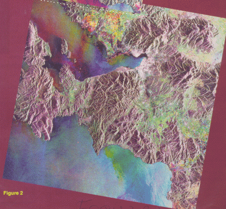
The brownish tones of mountains and hilly terrain reveal that there have been no substantial changes during the three years. The greenish tones in the lowlands, however, indicate a high soil humidity at the time of the 8 April 1993 data acquisition.
Agricultural areas, with their clear filed structure, can be recognised by their green, magenta, red, yellow and white colours. The green and white tones most likely correspond to unchanged crop types or land-use areas, whilst magenta, red and yellow tones reveal a change from early crops (cereals) to late crops (corn, tobacco, etc.). Greenish-blue hues represent the transition from late to early crops.
As far as changes in the urban areas are concerned, the green and blue dots probably indicate new settlements in the years between 1992 and 1995.
It is the Agency's hope that the uninterrupted availability of such unique data as these from the European Remote-Sensing Satellites ERS-1 and ERS-2, and their future successor Envisat, will serve ad a constant source of encouragement for the remote- sensing user community's activities in the critical domain of environmental change detection.


 ESA Bulletin Nr. 87.