Galileo, how you’ve grown
Today Galileo is the world’s most precise satellite navigation system, delivering metre-level accuracy, and if you are a modern smartphone owner then you – like nearly four billion others around the world – are among its users. This week we are celebrating that almost exactly a decade ago, on 12 March 2013, Europe for the first time ever was able to determine a position on the ground using only its own independent navigation system, Galileo.

Historic fix at ESTEC
The site where that historic first fix took place was ESA’s Navigation Laboratory at the Agency’s European Space Technology and Research Centre (ESTEC), beside the dunes of the Dutch North Sea coast. People who had been working towards this moment for years gathered within an equipment-lined room whose roof was studded with antennas. All they could do after that was wait and hope the stars – and satellites – aligned.
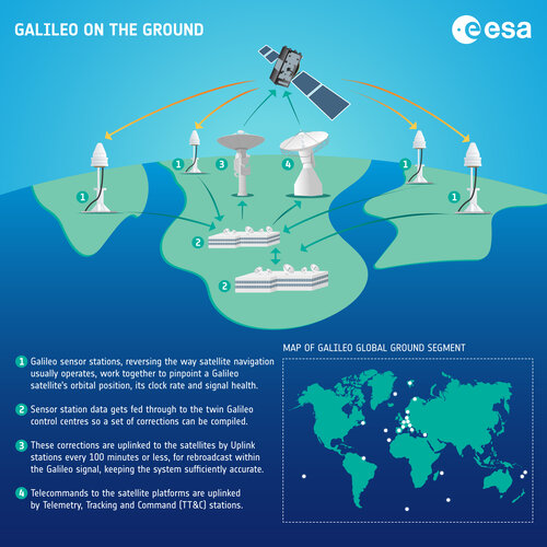
“This fix relied on an entirely new European infrastructure procured within ESA’s GalileoSat Programme, from the first four operational satellites in space to the two control centres in Italy and Germany linked to a global network of ground stations deployed in remote European territories across the world.” recalls Javier Benedicto, ESA Director of Navigation, who was there in the room that day.

“Of course, the workings of the system had been exhaustively modelled and simulated. But the essential step to demonstrate that the Galileo system actually performed as planned was to try it out for real – and this was the first time we could do that.”
European partnership makes Galileo a reality
It had taken years of steady effort to reach this point. Already in 1993, ESA started its first programme towards the conception of European satellite navigation infrastructure, consisting of two phases, GNSS-1 which later became EGNOS, and GNSS-2 which later became Galileo. This early work took place already in close partnership with Eurocontrol, the European Organisation for the Safety of Air Navigation, the European Commission and European air traffic services providers.
Javier Benedicto adds: "It really took the combination of technical and political impulses of respectively ESA and the European Union to make Galileo a reality, including the setting up of what would later become EUSPA, the European Union Agency for the Space Programme, which is tasked with operating the system and forging the all-important link to users and the marketplace.”
From launch to first fix
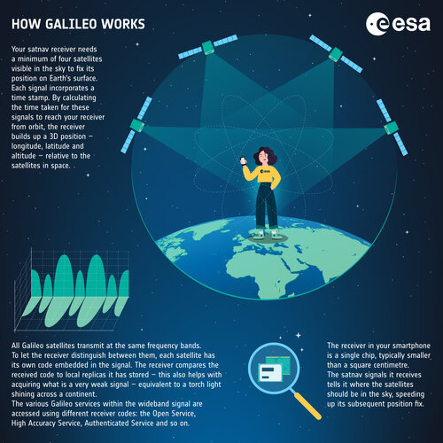
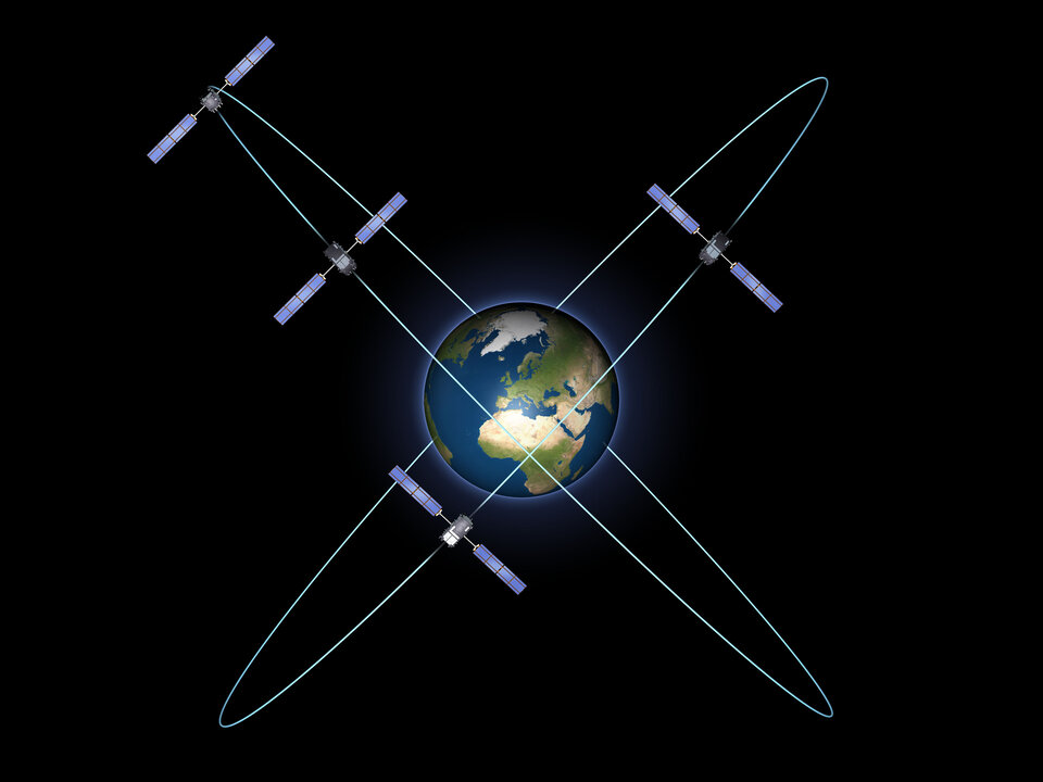
The first two pairs of Galileo ‘In-Orbit Validation’ satellites were launched in 2011 and 2012 – since it takes a minimum of four satellites to perform a navigation fix, one each for latitude, longitude, and altitude, plus one for time synchronisation. Once launched, the satellites had to undergo stringent in-orbit testing.
“Over the preceding days there was a lot of effort in the Galileo Control Centres in Fucino, Italy, and Oberpfaffenhofen, Germany, to properly configure the satellites and prepare for the generation of the navigation message they would broadcast,” explains Marco Falcone, heading ESA’s Galileo First Generation Programme.
Ready, set, fix
“Timing was important because with only four satellites, sufficient coverage to achieve a navigation fix was only available between two and three hours per day. And at the same time, we wanted to be the first to make the positioning fix, after all the hard work we’d put in! Therefore, the satellites navigation message broadcasts were turned on earlier that morning, immediately before they passed over Europe. In fact, we used our Galileo Experimental Sensor Stations connected to the lab at ESTEC to check that the signals were looking healthy, while we got ready over at ESTEC with a prototype receiver to compute the positioning.”
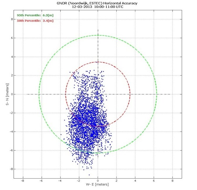
As the quartet of satellites appeared over the western horizon, the rooftop antennas picked up their signals and a prototype of a commercial receiver was employed to perform the fix. The results were displayed as recurring dots on a display to plot the position, within a set of concentric circles.

“We achieved a horizontal and vertical accuracy between 10 and 15 metres” adds Javier Benedicto. “This was within expectations, considering the limited number of satellites and ground infrastructure deployed. And at the time we were thrilled: it worked! We’d done it! This was the very first positioning fix performed using solely European infrastructure. And with many more satellites, ground systems and performance refinements on the way, it was only going to get better.”
From one fix to a billion fixes
Further ‘Full Operational Capability’ satellites followed rapidly, tested at ESTEC before being launched by Soyuz and Ariane 5 from French Guiana. A huge milestone was the declaration of Galileo Initial Services availability at the end of 2016, when guaranteed services to users began to be provided via EUSPA, then called GSA.

This was the point when mass market manufacturers began to turn towards Galileo’s opportunities, lured by the improved positioning performance that the system offers, and began to produce Galileo-ready smartphones and other devices in ever greater numbers – check the Use Galileo webpage for the current count.
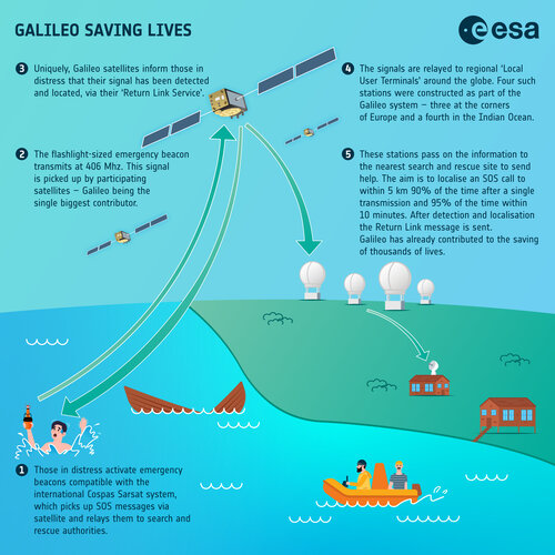
As the system was ramped up with more launches, it also began to serve as part of an international system for search and rescue, with satellites picking up distress calls for relay to emergency centres. Since then, Galileo has contributed to the saving of thousands of lives. Galileo is also serving as part of Europe’s E-Call system, involving the automatic calling of emergency services in the event of a serious road accident, fitted into all new European cars.

Meanwhile ESTEC’s Navigation Laboratory, working alongside EUSPA, continues to play a fundamental role in testing new Galileo services, such as the Open Service Navigation Message Authentication and the 20-cm-level High Accuracy Service.
Galileo of the future
Galileo itself, under the programme lead and funding of the European Commission, will continue to grow, with 10 more Galileo First Generation satellites planned for launch in the next few years, followed by enhanced-capability Galileo Second Generation satellites which are currently being built for testing and qualification at ESTEC, in order to continue to serve the citizens of Europe and the world at large with accurate, reliable and freely available navigation services.

Javier Benedicto concludes: “Galileo has delivered added value to worldwide users and sovereignty to Europe in the crucial sector of satellite navigation, which has grown into the single largest downstream space market, underpinning many elements of the European economy. It has been a privilege to work on, alongside the European Commission, EUSPA and our many industrial and academic partners across our continent - and the best is yet to come.”
About Galileo
Galileo is currently the world’s most precise satellite navigation system, serving close to four billion users around the globe. All smartphones sold in the European Single Market are now guaranteed Galileo-enabled. In addition, Galileo is making a difference across the fields of rail and maritime transportation, agriculture, financial timing services and rescue operations.
Galileo is a flagship programmes of the EU Space Programme, managed and funded by the European Union. Since its inception, ESA has been leading the design and development of the space and ground systems, as well as procuring launches. EUSPA (the EU Agency for the Space Programme) acts as the service provider of Galileo, overseeing the market and application needs and closing the loop with users.
For more info about Galileo: https://www.usegalileo.eu/.


Access the video


 Germany
 Austria
 Belgium
 Denmark
 Spain
Spain
 Estonia
 Finland
 France
 Greece
 Hungary
 Ireland
 Italy
Italy
 Luxembourg
 Norway
 The Netherlands
 Poland
 Portugal
 Czechia
 Romania
 United Kingdom
 Slovenia
 Sweden
 Switzerland


