Satellite data to improve flood forecasting
As the residents of Queensland, Australia, turn to the mammoth task of cleaning up after the devastating floods over the last weeks, data from ESA's Earth observation satellites are showing potential for delivering more timely warnings.
The floods in Queensland have been the worst in decades – and with high waters now hitting parts of the southern state of Victoria, this disaster is not over yet.
Although the heavy rains in Australia have been triggered by La Niña, it is thought that climate change may result in more frequent flood events. Clearly, it is becoming increasingly important to improve flood warning and monitoring systems.
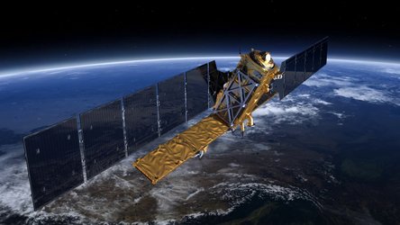
Through a project funded by ESA's Data User Element, observations from the Advanced Synthetic Aperture Radar (ASAR) on Envisat are now used to increase the reliability of information that is fed into models for monitoring and forecasting floods.

The Share project is being carried out by the Vienna University of Technology in collaboration with the Australian Commonwealth Scientific and Research Organisation (CSIRO).
CSIRO is developing a system to monitor and forecast the progression of floods for better water management. Currently, the system relies on optical data combined with passive microwave information and digital elevation models to identify volumes of water.
To increase the accuracy and reliability of the system, and to compensate for the limited resolution of passive microwave data along with the fact that optical instruments can not 'see' through clouds, information derived from ASAR is being incorporated into the system.
The animation above shows values of soil moisture derived from ASAR over the eastern part of Australia. The blue values show the highly saturated soils.

Wolfgang Wagner from the Vienna University of Technology said, "As demonstrated by the Share project, SAR data, such as that provided by Envisat and the future Sentinel-1 satellites, can be used in two important ways for flood monitoring.
"Firstly, the data can be used to continuously monitor how much water is stored in the soil as this determines the amount of runoff resulting from rain and secondly, by observing inundated areas during a flood because radar can penetrate through clouds and even rain."
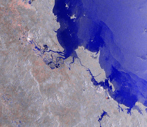
The image on the left shows how the backscatter signal provided by ASAR Wide Swath mode data can be used to extract flooding information.
Albert van Dijk from CSIRO said, "In Australia we have learned to live with droughts and floods. Extreme floods cause terrible damage, but in other cases floods are vital for our river wetlands and irrigation communities.
"ESA's radar observations are helping us develop ways to monitor and predict the progression of floods."

Looking to the future, when ESA's first Sentinel-1 mission is launched in 2013, operational forecasting is expected to improve significantly. Sentinel-1 is one of the five missions being built specifically for Europe's Global Monitoring for Environment and Security (GMES) programme.
ESA's SMOS water mission has also been providing highly accurate information on the dynamics of soil wetness. This information is highly valuable to assess how much water can be stored in the soil before runoff occurs, which should result in more accurate forecasts of floods and droughts.


 Germany
 Austria
 Belgium
 Denmark
 Spain
Spain
 Estonia
 Finland
 France
 Greece
 Hungary
 Ireland
 Italy
Italy
 Luxembourg
 Norway
 The Netherlands
 Poland
 Portugal
 Czechia
 Romania
 United Kingdom
 Slovenia
 Sweden
 Switzerland


