Germany
 Austria
 Belgium
 Denmark
 Spain
Spain
 Estonia
 Finland
 France
 Greece
 Hungary
 Ireland
 Italy
Italy
 Luxembourg
 Norway
 The Netherlands
 Poland
 Portugal
 Czechia
 Romania
 United Kingdom
 Slovenia
 Sweden
 Switzerland


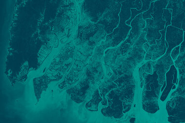
IRIDE first image presented at ESA–ESRIN
The first image from a new Italian Earth observation satellite mission was published today: a high-resolution image of a strip of the Italian peninsular showing the city of Rome at a resolution of 2.66 metres. This is three times higher than the resolution currently available for systematic acquisition over Italy.

The image was taken by a multispectral optical instrument on board the first IRIDE microsatellite, the Pathfinder Hawk, which was launched on 14 January this year. The IRIDE constellation of satellites are tailored to provide information for a wide range of environmental, emergency and security services for Italy.
The image was captured on the 5 March 2025, during a passage over central Italy from the town of Fano on the Adriatic coast, over the central Apennine ridge, all the way down to Rome and, about 20 km further south, to Ostia on the coast of Lazio.
IRIDE is an ambitious Italian space programme, initiated by the Italian government and developed with funding from Italy’s National Recovery and Resilience Plan (PNRR).
Coordinated by ESA with support from the Italian Space Agency (ASI), the IRIDE programme involves the deployment of six satellite constellations, which together can potentially include more than 60 satellites.
The first image was presented at an event today at ESA-ESRIN, ESA's establishment in Italy.
New Earth observation services for Italy


Access the video
This first images from the IRIDE constellation mark the start of a generation of optical multispectral images from satellites entirely designed and integrated in Italy.
Data from IRIDE’s satellites will be used to map and monitor coastal and marine zones, helping to protect the cultural and environmental heritage of Italy’s coastlines. The programme will also contribute data to monitoring air quality, land cover, climate and water resources; mapping land motion (for example, due to volcanoes, earthquakes or subsidence); as well as emergency and security services.
Many of the services will be available to local and regional public authorities in Italy, signalling an increase in the use of satellite technology in the routine activities related to managing local urban or rural environments. For example, IRIDE will provide services to help manage town and city planning, monitor changes in land coverage, and the effects of urban heat islands.
“These first images show the extraordinary potential of IRIDE, made possible thanks to the skills and motivation of the teams from ESA, ASI and Italian industry, said ESA’s Head of Earth Observation Programmes, Simonetta Cheli.
She added, “I would like to congratulate Argotec, Officina Stellare, Exprivia and all the companies involved in the creation of this constellation. Thanks to the trust placed in us by the Italian government and the solid collaboration between ESA and ASI, the programme is proceeding with great success.”
And according to Teodoro Valente, president of ASI, IRIDE demonstrates Italy’s commitment to investing in research and innovation to address future challenges. He noted, “This success is the result of teamwork that sees Italy as a protagonist in space. We will continue to work with determination to ensure that this constellation reaches its full operational capacity, respecting the objectives of the PNRR and providing valuable data for our country and the international community.”
A model for future constellations
Pathfinder Hawk is an exploratory model satellite for one of the IRIDE constellations, Hawk for Earth Observation (HEO), which was developed by a consortium led by Turin-based company Argotec. Its instrument has a ground sampling distance of 2.66 m, which means each pixel in the image covers 2.66 m, from an orbit altitude of 590 km. It can acquire in panchromatic and seven spectral bands going from RGB to near infrared and red edge.
The CEO of Argotec, David Avino, said, “This first image taken over Italy is an historic moment for the country and an important milestone in the field of Earth observation. This result confirms Argotec's know-how and the reliability of our satellite platforms.”
About IRIDE

The IRIDE programme has a budget of €1.1 billion, most of which comes from the PNRR, Italy’s post-Covid economic recovery and modernisation fund, while the remainder is from Italy’s Complementary National Plan. It is the result of collaboration between more than 70 companies across Italy.
ESA is responsible for defining, implementing and commissioning the IRIDE system, through an agreement with the Italian government. ESA oversees industrial activities during the implementing and commissioning phases, until the system is transferred to ASI for the operational phase.
Completing the constellations
With further launches scheduled for June and November 2025, the programme will be fully operational by June 2026. In the coming months, Pathfinder Hawk will be joined by other satellites in the IRIDE group of constellations.
The six IRIDE constellations are:
- SAR constellation #1 (synthetic aperture radar (SAR) instruments)
- SAR constellation #2 (synthetic aperture radar (SAR) instruments)
- Very high-resolution optical constellation (optical instruments)
- Hyperspectral constellation (hyperspectral optical instruments)
- High-resolution multispectral constellation #1 (multispectral optical instruments)
- High-resolution multispectral constellation #2 (multispectral optical instruments)
ESA’s Simonetta Cheli added, “As Italians and Europeans, we can be proud of IRIDE, a programme that continues to grow and strengthen our capabilities in the space sector, thanks to the collaboration between institutions and industry.”