Germany
 Austria
 Belgium
 Denmark
 Spain
Spain
 Estonia
 Finland
 France
 Greece
 Hungary
 Ireland
 Italy
Italy
 Luxembourg
 Norway
 The Netherlands
 Poland
 Portugal
 Czechia
 Romania
 United Kingdom
 Slovenia
 Sweden
 Switzerland


Introducing MetOp-SG
Data from the first-generation MetOp satellites have been the most significant factor in enhancing the accuracy of European weather forecasts for periods ranging from 12 hours to 10 days. But now it’s time for the MetOp-Second Generation mission, or MetOp-SG for short, to take over the reigns – not only ensure the continuity of global observations from polar orbit for weather forecasting and climate analysis, but to do it even better.
The weather shapes countless facets of daily life, impacting public health, well-being and the economy, and the success and efficiency of key sectors such as agriculture, business, commerce, industry, transportation and marine operations all rely heavily on accurate forecasts.

As climate change intensifies, extreme weather events are becoming more frequent and more severe. With increasingly erratic weather patterns, timely and precise forecasting has never been more crucial.
Data gathered by original MetOp series of three satellites since 2006, have had the biggest impact on the accuracy of numerical weather prediction. These satellites circle Earth from pole to pole as the planet rotates beneath them, covering the globe approximately every 24 hours. In addition, their relatively low orbital altitude enables them to capture highly detailed measurements of various atmospheric conditions.
This capability is complemented by Europe’s other main weather mission, the Meteosat series, that operate in geostationary orbit. Positioned around 36 000 km above the equator, these satellites remain fixed relative to Earth’s rotation. This fixed high-altitude geostationary orbit allows a large portion of Earth’s surface to be in constant view to monitor fast-evolving weather systems.
With their different perspectives on Earth, having both types of weather mission in orbit maximises the effectiveness of data delivery for weather forecasting, prediction models and climate analysis.
Taking weather forecasting from polar orbit to a new level
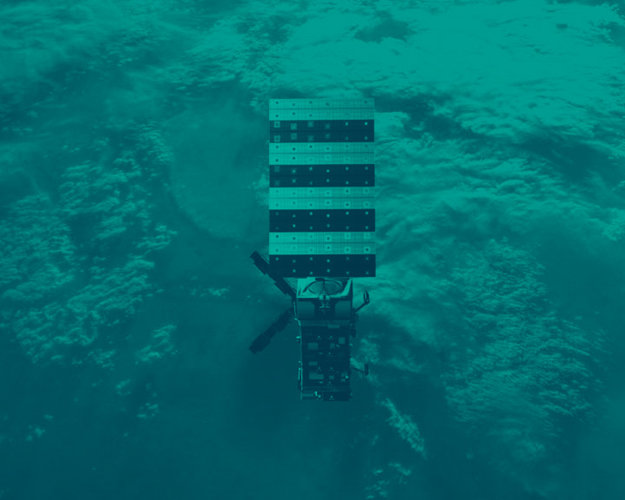
Unlike the original MetOp series of three successive single satellites, the all-new MetOp-SG mission comprises three successive pairs of satellites.

Each MetOp-SG pair is made up of an A-type and a B-type satellite that carry a different, but complementary, suite of remarkable instruments.
The package totals ten different instruments across both satellites, some of which are based on the sound heritage of the first MetOp series, and some of which are completely new.
The A-type satellites carry six instruments: a next-generation infrared atmospheric sounder, a microwave sounder, a multispectral imaging radiometer, a novel multiviewing, multichannel, multipolarisation imager, a radio occultation sounder (which is also embarked on the MetOp-B satellites), and the Copernicus Sentinel-5 spectrometer.
The type-B satellites carry five instruments: a scatterometer, the other radio occultation sounder, a novel microwave imager, a novel ice-cloud imager, and an Argos-4 data collection system.
Carrying such comprehensive sets of instruments, both types are large satellites, each weighing around 4000 kg, comparable to a small lorry.

Not only does the MetOp-SG mission ensure continuity of data from polar orbit for numerical weather prediction, weather forecasting and climate analysis, it improves on the accuracy and resolution of the original MetOp mission, and adds new measurements to its list of deliverables.
Working together, and orbiting 90 degrees apart, the MetOp-SG satellites provide, for example, high-resolution observations of temperature, precipitation, clouds, winds, sea ice, aerosols, soil moisture, volcanic dust, air pollution and a multitude of other parameters.
These data are not only used for weather prediction and climate research, but also for operational services related to atmospheric chemistry, oceanography and hydrology.
The design lifespan of each satellite in orbit is 7.5 years, with subsequent satellites of each series launched at seven-year intervals to achieve a total mission life of more than two decades.
The first MetOp-SG-A is scheduled to launch in summer 2025 followed by the first MetOp-SG-B in 2026.

Like the original MetOp mission, MetOp-SG is part of the Joint Polar System – a cooperative venture between Europe and the US – to deliver meteorological data from polar orbit, free of charge, to users worldwide. Europe is responsible for the ‘mid-morning orbit’ and the US is responsible for the ‘afternoon orbit’.
The mission is thanks to the long-standing cooperation between ESA and Eumetsat, where ESA is responsible for designing and building the satellites, and Eumetsat procures the launch service, develops the ground segment, operates the satellites and provides the data to the worldwide meteorological user community.
Two instruments are being provided by the French Space Agency CNES, and one by the German Aerospace Centre DLR. In addition, the European Commission is providing, through Copernicus, the Sentinel-5 instrument.
The prime contractors for the mission are Airbus Defence and Space in Toulouse, France, for the A-type satellites, and Airbus Defence and Space in Friedrichshafen, Germany, for the B-type. The mission brings together over 110 companies under 280 contracts across 16 European countries, with more than 2000 people contributing daily.