About ESA
The European Space Agency (ESA) is Europe’s gateway to space. Its mission is to shape the development of Europe’s space capability and ensure that investment in space continues to deliver benefits to the citizens of Europe and the world.
Highlights


Latest


Space in Member States
Find out more about space activities in our 23 Member States, and understand how ESA works together with their national agencies, institutions and organisations.
 Germany
 Austria
 Belgium
 Denmark
 Spain
Spain
 Estonia
 Finland
 France
 Greece
 Hungary
 Ireland
 Italy
Italy
 Luxembourg
 Norway
 The Netherlands
 Poland
 Portugal
 Czechia
 Romania
 United Kingdom
 Slovenia
 Sweden
 Switzerland
Science & Exploration
Exploring our Solar System and unlocking the secrets of the Universe
Go to topicAstronauts


Latest


Enabling & Support
Making space accessible and developing the technologies for the future
Go to topicLatest


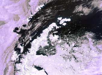
Antarctic Peninsula - MERIS - 24 March 2002
The Antarctic Peninsula, visible on the left side of this image, extends for 1000 km in a south-north direction and is situated between the Bellingshausen Sea on the west and the Weddell Sea on the east.
This region has experienced exceptional atmospheric warming since the 1950s and is therefore of key interest for global change research. Over the last 50 years an average temperature increase of 2.5°C has been observed at the climate stations on the Peninsula. This has triggered the retreat and break-up of several ice shelves, culminating in the collapse of the two northern parts of the Larsen Ice Shelf in January 1995 (Larsen A) and in March 2002 (Larsen B). Some of the icebergs results of this collapse can be distinguished under the cloud layer.
Technical Information:
Instrument: Medium Resolution Imaging Spectrometer (MERIS)
Date of Acquisition: 24 March 2002
Orbit number: 335
Instrument features: Full resolution image (300-meter resolution)