About ESA
The European Space Agency (ESA) is Europe’s gateway to space. Its mission is to shape the development of Europe’s space capability and ensure that investment in space continues to deliver benefits to the citizens of Europe and the world.
Highlights


Latest


Space in Member States
Find out more about space activities in our 23 Member States, and understand how ESA works together with their national agencies, institutions and organisations.
 Germany
 Austria
 Belgium
 Denmark
 Spain
Spain
 Estonia
 Finland
 France
 Greece
 Hungary
 Ireland
 Italy
Italy
 Luxembourg
 Norway
 The Netherlands
 Poland
 Portugal
 Czechia
 Romania
 United Kingdom
 Slovenia
 Sweden
 Switzerland
Science & Exploration
Exploring our Solar System and unlocking the secrets of the Universe
Go to topicAstronauts


Latest


Enabling & Support
Making space accessible and developing the technologies for the future
Go to topicLatest


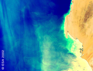
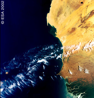
Upwelling off the coast of Mauritania
One of the first photos taken by Envisat, ESA's Earth observation satellite in March 2002.
Just as some areas of land are more fertile than others, the same is also true of the Earth’s oceans, these are known as “upwelling areas”. Using ASAR and MERIS together, Envisat has imaged one such upwelling area off the coast of Mauritania, in northwest Africa. The Envisat ASAR image shown here illustrates how the upwelling formed. Upwellings are driven primarily by winds. On this image, a brighter water surface indicates a stronger wind, while surface line patterns indicate wind direction. In this case, trade winds blowing water to the continent’s edge pump deep water rich in nutrients to the surface, which causes a population explosion in local marine life, starting with the phytoplankton.