About ESA
The European Space Agency (ESA) is Europe’s gateway to space. Its mission is to shape the development of Europe’s space capability and ensure that investment in space continues to deliver benefits to the citizens of Europe and the world.
Highlights


Latest


Space in Member States
Find out more about space activities in our 23 Member States, and understand how ESA works together with their national agencies, institutions and organisations.
 Germany
 Austria
 Belgium
 Denmark
 Spain
Spain
 Estonia
 Finland
 France
 Greece
 Hungary
 Ireland
 Italy
Italy
 Luxembourg
 Norway
 The Netherlands
 Poland
 Portugal
 Czechia
 Romania
 United Kingdom
 Slovenia
 Sweden
 Switzerland
Science & Exploration
Exploring our Solar System and unlocking the secrets of the Universe
Go to topicAstronauts


Latest


Enabling & Support
Making space accessible and developing the technologies for the future
Go to topicLatest


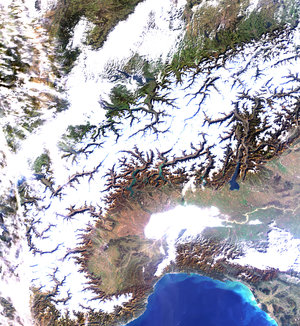
Austria - MERIS - 31 May 2002
Austria and Switzerland Alpine regions are clearly visible on this Medium Resolution Imaging Spectrometer (MERIS) image. Snow still remains on the higher peaks with vegetated valleys in between. A second range of mountains, the Apennines, again with snow covered higher peaks, can be seen extending down the boot of Italy. To the north of these mountains, below the Alps, is the green lake-land region of northern Italy.
MERIS was originally designed for ocean-colour monitoring but the outstanding radiometric quality of its five cameras enables land observations as well. The MERIS Global Vegetation Index, an ESA-derived product, has been developed in order to identify and distinguish the various types of vegetation and forests at regional scales. It should be of great help to those involved in research fields such as: deforestation monitoring, forest inventory and carbon cycle related issues. It will be soon delivered to users all over the world together with the many other geophysical products focusing on key parameters of our biosphere. Ocean, land and atmosphere will be studied by MERIS and its measurements will help us to better understand the climatic and environmental changes of our planet.
Technical Information:
Instrument: MEdium Resolution Imaging Spectrometer (MERIS)
Date of Acquisition: 31 May 2002
Orbit number: 01307
Instrument features: Reduced Resolution image (1200-meter resolution)