About ESA
The European Space Agency (ESA) is Europe’s gateway to space. Its mission is to shape the development of Europe’s space capability and ensure that investment in space continues to deliver benefits to the citizens of Europe and the world.
Highlights


Latest


Space in Member States
Find out more about space activities in our 23 Member States, and understand how ESA works together with their national agencies, institutions and organisations.
 Germany
 Austria
 Belgium
 Denmark
 Spain
Spain
 Estonia
 Finland
 France
 Greece
 Hungary
 Ireland
 Italy
Italy
 Luxembourg
 Norway
 The Netherlands
 Poland
 Portugal
 Czechia
 Romania
 United Kingdom
 Slovenia
 Sweden
 Switzerland
Science & Exploration
Exploring our Solar System and unlocking the secrets of the Universe
Go to topicAstronauts


Latest


Enabling & Support
Making space accessible and developing the technologies for the future
Go to topicLatest


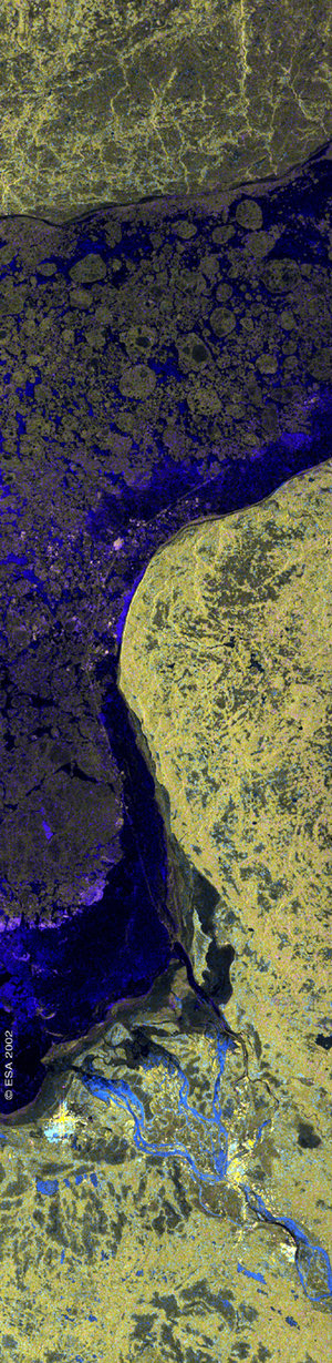
Sweden - ASAR - 8 April 2002
The image, 100km wide, shows southwest Sweden and the Kattegat. Just visible in the southwest is the tip of Sjælland, Denmark, and the edge of the city of Copenhagen. In The Sound, an important shipping route into the Baltic Sea between Denmark and Sweden, several ships are visible as bright specks in the dark water. Further north, at the top left of the image, a ship’s wake can be seen.
The image is a colour composite generated using ASAR’s Alternating Polarisation (AP) mode. The red channel contains the VV polarised image, the green channel contains the HH polarised image and the blue channel contains the magnitude of the difference between the amplitudes in VV and HH.
Copenhagen and the Swedish cities of Helsingborg and Halmstad are visible as bright yellow patches due to high reflectance in both VV and HH polarisations. Surrounding them, and stretched along the coast are agricultural regions, which appear as distinctly textured areas in the image, where VV-polarised reflectance generally dominates, creating purplish tones. Inland, the majority of the terrain is typically Swedish, dominated by forest (medium backscatter in VV and HH) and punctuated with small lakes.
The radar also reveals patterns on the surface of the water. The darker areas show sheltered water close to the shore. In The Sound, the juxtaposition of calm and choppy water reflects the flow of tidal currents through this narrow channel. The yellow regions on the far left display areas of high winds while surface current features generate the curved lines visible off the Swedish coast.
Technical Information:
Instrument: Advanced Synthetic Aperture Radar (ASAR)
Mode: Image Swath 2
Acquisition date: 08 April 2002
Orbit number: 00555
Orbit direction: Ascending
Polarisation: VV-HH
Resolution: 25 metres