About ESA
The European Space Agency (ESA) is Europe’s gateway to space. Its mission is to shape the development of Europe’s space capability and ensure that investment in space continues to deliver benefits to the citizens of Europe and the world.
Highlights


Latest


Space in Member States
Find out more about space activities in our 23 Member States, and understand how ESA works together with their national agencies, institutions and organisations.
 Germany
 Austria
 Belgium
 Denmark
 Spain
Spain
 Estonia
 Finland
 France
 Greece
 Hungary
 Ireland
 Italy
Italy
 Luxembourg
 Norway
 The Netherlands
 Poland
 Portugal
 Czechia
 Romania
 United Kingdom
 Slovenia
 Sweden
 Switzerland
Science & Exploration
Exploring our Solar System and unlocking the secrets of the Universe
Go to topicAstronauts


Latest


Enabling & Support
Making space accessible and developing the technologies for the future
Go to topicLatest


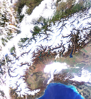
Switzerland – MERIS, 01 December 2002, ASAR, 06 November 2002
This image shows an area centred over Switzerland (red vector outline) where subsets acquired by two different sensors, MERIS and ASAR onboard Europe's Envisat Environment satellite, have been combined. One of the main advantages of this image is that it shows the new application capabilities offered by Envisat. While the basic image in colour was acquired by the Medium Resolution Imaging Spectrometer MERIS (FR-Mode, 300m resolution) on December 1, 2002, the black and white data overlay was collected by the Advanced Synthetic Aperture Radar ASAR (VV-Polarisation, 150m resolution, IS2 swath) on November 6, 2002. The MERIS and ASAR images were geocoded using a digital elevation model in the Swiss oblique Mercator map projection. In the case of the ASAR image mode medium resolution (IMM) product, the terrain-geocoding operation corrected the geometric distortion (layover and foreshortening) inherent to any SAR acquisition over mountainous areas, by transforming the image from radar geometry (accounting for the IMM's multiple ground to slant range references) to map geometry (Swiss map coordinates).
Image geocoding performed by RSL/NPOC, University of Zurich, Switzerland.
Technical Information:
Instruments: MEdium Resolution Imaging Spectrometer (MERIS)Advanced Synthetic Aperture Radar (ASAR)
Date of Acquisition: 01 December 2002 (MERIS) 06 November 2002 (ASAR)
Orbit number: 3941 (MERIS) 3583 (ASAR)
Orbit direction: Descending
Instrument features: Full Resolution image (300-metre resolution)
Image Mode Medium (150-metre resolution)