About ESA
The European Space Agency (ESA) is Europe’s gateway to space. Its mission is to shape the development of Europe’s space capability and ensure that investment in space continues to deliver benefits to the citizens of Europe and the world.
Highlights


Latest


Space in Member States
Find out more about space activities in our 23 Member States, and understand how ESA works together with their national agencies, institutions and organisations.
 Germany
 Austria
 Belgium
 Denmark
 Spain
Spain
 Estonia
 Finland
 France
 Greece
 Hungary
 Ireland
 Italy
Italy
 Luxembourg
 Norway
 The Netherlands
 Poland
 Portugal
 Czechia
 Romania
 United Kingdom
 Slovenia
 Sweden
 Switzerland
Science & Exploration
Exploring our Solar System and unlocking the secrets of the Universe
Go to topicAstronauts


Latest


Enabling & Support
Making space accessible and developing the technologies for the future
Go to topicLatest


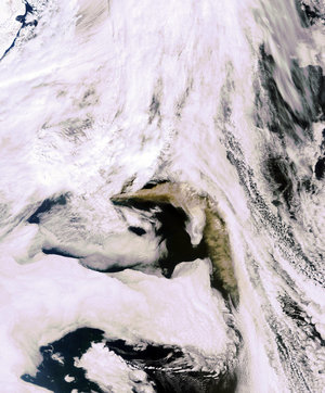
Iceland - MERIS, 23 May 2003
This MEdium Resolution Imaging Spectrometer (MERIS) image shows Iceland. This mountainous island country is situated in the northern Atlantic Ocean, about 200 kilometres southeast of Greenland. Iceland lies on top of a fault in the Earth's crust, which allows underground heat to escape as steam.
Gulf Stream currents flow around the south, west and north coasts, bringing mild, wet weather that warms the coastal lowlands (just one-quarter of the island) being the only inhabitable region of Iceland. Reykjavik, the capital of Iceland, can be seen in the southwest of the island in grey tones. This city is the northernmost national capital in the world. Numerous river plains can be seen in the image along the coastline. The westernmost part of Iceland (top left of the image covered by snow) is a peninsula linked to the rest of the island by an isthmus only 12 kilometres wide at its narrowest point. It features Iceland's most spectacular fjords.
Glaciers cover about one-eighth of the country's surface. The largest, Vatnajokull, is situated on the southeastern edge of the island. In addition to these ice fields, the island is home to over 200 volcanoes, many of which are still active. Volcanic eruptions are frequent and volcanic ash deposits are widespread. Many glaciers of Iceland rest above active volcanoes. Beneath the enormous glacier, the intense geothermal activity continuosly melts the ice to form a sub-glacial lake in the volcano's caldera. The melt waters eventually flood the caldera, and pour out from underneath the glacier.
Technical Information:
Instrument: MEdium Resolution Imaging Spectrometer (MERIS)
Date of Acquisition: 23 May 2003
Orbit number: 06419
Orbit direction: Descending
Instrument features: Full Resolution image (300 metre resolution)
Band combination: R = 665 nm, G = 560 nm, B = 442.5 nm