
About ESA
The European Space Agency (ESA) is Europe’s gateway to space. Its mission is to shape the development of Europe’s space capability and ensure that investment in space continues to deliver benefits to the citizens of Europe and the world.
Highlights


Latest


Space in Member States
Find out more about space activities in our 23 Member States, and understand how ESA works together with their national agencies, institutions and organisations.
 Germany
 Austria
 Belgium
 Denmark
 Spain
Spain
 Estonia
 Finland
 France
 Greece
 Hungary
 Ireland
 Italy
Italy
 Luxembourg
 Norway
 The Netherlands
 Poland
 Portugal
 Czechia
 Romania
 United Kingdom
 Slovenia
 Sweden
 Switzerland
Science & Exploration
Exploring our Solar System and unlocking the secrets of the Universe
Go to topicAstronauts


Latest


Enabling & Support
Making space accessible and developing the technologies for the future
Go to topicLatest


South of Italy - MERIS - 10 October 2003
This Medium Resolution Imaging Spectrometer (MERIS) image shows the southern part of Italy. Visible landmarks in the Italian Peninsula are the Gulf of Naples on the west coast with the city seen in bright colour and the Mount Vesuvius while on the other side of the peninsula the cities and towns of the Puglia region are clearly visible. Sicily, the largest island in the Mediterranean Sea, is seen in the bottom part of the image, separated form mainland Italy by the Strait of Messina. Etna, the Europe's highest and most active volcano is clearly visible on the east coast of the island.
Technical Information:
Instrument: MEdium Resolution Imaging Spectrometer (MERIS)
Date of Acquisition: 10 October 2003
Orbit number: 08421
Orbit direction: Descending
Instrument features: Full Resolution image (300 metre resolution)
Band combination: R = 665 nm, G = 560 nm, B = 442.5 nm
Coordinates:
NE Lat/Long: N 41.11 / E 19.68
NW Lat/Long: N 42.44 / E 12.90
SW Lat/Long: N 36.64 / E 11.27
SE Lat/Long: N 35.37 / E 17.54
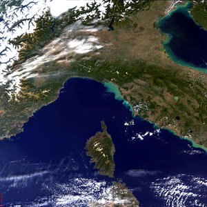
Central Italy and Island of Corse - MERIS - 6 October 2003

Southern Italy - MERIS, 21 June 2003

Goteborg, Sweden - MERIS - 12 October 2003

France, Italy, and the northern Mediterranean - MERI…
