About ESA
The European Space Agency (ESA) is Europe’s gateway to space. Its mission is to shape the development of Europe’s space capability and ensure that investment in space continues to deliver benefits to the citizens of Europe and the world.
Highlights


Latest


Space in Member States
Find out more about space activities in our 23 Member States, and understand how ESA works together with their national agencies, institutions and organisations.
 Germany
 Austria
 Belgium
 Denmark
 Spain
Spain
 Estonia
 Finland
 France
 Greece
 Hungary
 Ireland
 Italy
Italy
 Luxembourg
 Norway
 The Netherlands
 Poland
 Portugal
 Czechia
 Romania
 United Kingdom
 Slovenia
 Sweden
 Switzerland
Science & Exploration
Exploring our Solar System and unlocking the secrets of the Universe
Go to topicAstronauts


Latest


Enabling & Support
Making space accessible and developing the technologies for the future
Go to topicLatest


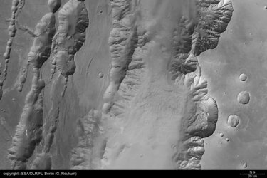
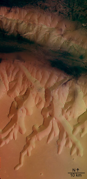
HRSC black and white image of Louros Valles
This image was taken by the High Resolution Stereo Camera (HRSC) on board ESA's Mars Express during orbit 97 from an altitude of 269 kilometres. The image has a resolution of about 13 metres per pixel and is centred at 278.8° East and 8.3° South. North is at the right.
The image shows a system of sapping channels, called Louros Valles (named in 1982 after river in Greece), south of the Ius Chasma canyon which runs east to west. The Ius Chasma belongs to the giant Valles Marineris canyon system. The Geryon Montes, visible at the northern images border, is a mountain range which divide the Ius Chasma into two parallel trenches. The dark deposits at the bottom of the Ius Chasma are possibly related to water and wind erosion.
'Sapping' is erosion by water that emerges from the ground as a spring or seeps from between layers of rock in a wall of a cliff, crater or other type of depression. The channel forms from water and debris running down the slope from the seepage area. This is known from similar features on Earth, but on Mars it is thought that most of the water had probably either evaporated or frozen by the time it reached the bottom of the slope.
HRSC colour image of Louros Valles

HRSC image of Louros Valles in 3D

Black and white view of Melas Chasma

Black and white view of Mangala Valles