Accept all cookies Accept only essential cookies See our Cookie Notice

About ESA
The European Space Agency (ESA) is Europe’s gateway to space. Its mission is to shape the development of Europe’s space capability and ensure that investment in space continues to deliver benefits to the citizens of Europe and the world.
Highlights
ESA - United space in Europe
This is ESA ESA facts Member States & Cooperating States Funding Director General Top management For Member State Delegations European vision European Space Policy ESA & EU Space Councils Responsibility & Sustainability Annual Report Calendar of meetings Corporate newsEstablishments & sites
ESA Headquarters ESA ESTEC ESA ESOC ESA ESRIN ESA EAC ESA ESAC Europe's Spaceport ESA ESEC ESA ECSAT Brussels Office Washington OfficeWorking with ESA
Business with ESA ESA Commercialisation Gateway Law at ESA Careers Cyber resilience at ESA IT at ESA Newsroom Partnerships Merchandising Licence Education Open Space Innovation Platform Integrity and Reporting Administrative Tribunal Health and SafetyMore about ESA
History ESA Historical Archives Exhibitions Publications Art & Culture ESA Merchandise Kids Diversity ESA Brand Centre ESA ChampionsLatest
Space in Member States
Find out more about space activities in our 23 Member States, and understand how ESA works together with their national agencies, institutions and organisations.
Science & Exploration
Exploring our Solar System and unlocking the secrets of the Universe
Go to topicAstronauts
Missions
Juice Euclid Webb Solar Orbiter BepiColombo Gaia ExoMars Cheops Exoplanet missions More missionsActivities
International Space Station Orion service module Gateway Concordia Caves & Pangaea BenefitsLatest
Space Safety
Protecting life and infrastructure on Earth and in orbit
Go to topicAsteroids
Asteroids and Planetary Defence Asteroid danger explained Flyeye telescope: asteroid detection Hera mission: asteroid deflection Near-Earth Object Coordination CentreSpace junk
About space debris Space debris by the numbers Space Environment Report In space refuelling, refurbishing and removingSafety from space
Clean Space ecodesign Zero Debris Technologies Space for Earth Supporting Sustainable DevelopmentApplications
Using space to benefit citizens and meet future challenges on Earth
Go to topicObserving the Earth
Observing the Earth Future EO Copernicus Meteorology Space for our climate Satellite missionsCommercialisation
ESA Commercialisation Gateway Open Space Innovation Platform Business Incubation ESA Space SolutionsLatest
Enabling & Support
Making space accessible and developing the technologies for the future
Go to topicBuilding missions
Space Engineering and Technology Test centre Laboratories Concurrent Design Facility Preparing for the future Shaping the Future Discovery and Preparation Advanced Concepts TeamSpace transportation
Space Transportation Ariane Vega Space Rider Future space transportation Boost! Europe's Spaceport Launches from Europe's Spaceport from 2012Latest

(2) Acheron Fossae horsts and grabens (black/white)
Thank you for liking
You have already liked this page, you can only like it once!
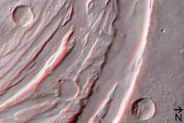
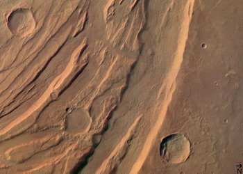
Image 2 of 6. These images were taken by the High Resolution Stereo Camera (HRSC) on board ESA’s Mars Express are of the Acheron Fossae region, an area of intensive tectonic (continental ‘plate’) activity in the past.
Acheron Fossae marks the northern edge of the Tharsis plateau. It is part of a network of extensional fractures that radiates outward from their central focus in the Tharsis ‘bulge’, a huge area of regional uplift where intensive volcanic activity occurred.
These curved ‘faults’ were caused in the process of this uplift: cracks in the crust formed when the hot material rising from deep in the mantle of Mars pushed the overlying ‘elastic’ lithosphere (surface layers of rock) upward. When the distorting tensions became too strong, the brittle crust on top of the lithosphere broke along zones of weakness.
Images 1-3, from orbit 37, are dominated by these curved features, showing a highly fractured, faulted and deformed area in the central part of the Acheron Fossae.
The feature is situated at approximately 35º-40º North and 220º-230º East, about 1000 kilometres north of the large Olympus Mons volcano.
For practical use on the internet, the images have been reduced in their resolution – the data originally obtained from orbit at an altitude of 765 kilometres (orbit 37) and 1240 kilometres (orbit 143) have a resolution of 30 metres and 50 metres per pixel respectively.
-
CREDIT
ESA/DLR/FU (G. Neukum) -
LICENCE
ESA Standard Licence

(5) Disrupted crater at Acheron Fossae in black/white

(3) Acheron Fossae horsts and grabens in 3D

(1) Acheron Fossae horsts and grabens in colour

Perspective view of Acheron Fossae


 Germany
 Austria
 Belgium
 Denmark
 Spain
Spain
 Estonia
 Finland
 France
 Greece
 Hungary
 Ireland
 Italy
Italy
 Luxembourg
 Norway
 The Netherlands
 Poland
 Portugal
 Czechia
 Romania
 United Kingdom
 Slovenia
 Sweden
 Switzerland


