About ESA
The European Space Agency (ESA) is Europe’s gateway to space. Its mission is to shape the development of Europe’s space capability and ensure that investment in space continues to deliver benefits to the citizens of Europe and the world.
Highlights


Latest


Space in Member States
Find out more about space activities in our 23 Member States, and understand how ESA works together with their national agencies, institutions and organisations.
 Germany
 Austria
 Belgium
 Denmark
 Spain
Spain
 Estonia
 Finland
 France
 Greece
 Hungary
 Ireland
 Italy
Italy
 Luxembourg
 Norway
 The Netherlands
 Poland
 Portugal
 Czechia
 Romania
 United Kingdom
 Slovenia
 Sweden
 Switzerland
Science & Exploration
Exploring our Solar System and unlocking the secrets of the Universe
Go to topicAstronauts


Latest


Enabling & Support
Making space accessible and developing the technologies for the future
Go to topicLatest


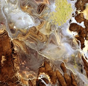
WSM/WSM InSAR of Algerian desert
Scan-SAR (or Wide Swath Mode (WSM)) is a particular Envisat ASAR operating mode that achieves very wide swath coverage by periodically switching the antenna pointing between several range subswaths. The sensor acquires in short bursts by cyclically scanning all the subswaths.
These images represent one of the first WSM/WSM interferometric pairs, possessing a swath depth of 400 km, unprecedented in other spaceborne SAR missions.
The data has been acquired in WSM on 14 September 2003 and 19 October 2003. Although ASAR WSM was not designed to maintain the burst synchronisation between different acquisitions, a rather high percentage of interferometric WSM pairs show partial burst synchronisation. The results here are derived from one of these pairs, compensated for topographic effects by using an available digital elevation model (DEM).
The images cover an area in central Algeria, including the Tademait Plateau (centre), Ouet Essaul Mellene (left) and Ouet Djaret (higher left). The Tademait area between El Golea and In Salah is a quite flat area in the middle of the Sahara where coherence is maintained over a long time period.
This images corresponds to the amplitude, colour-coded with interferometric phase. The image is in slant projection, oriented with north-west corner up-left, and the area covered is 204 km (azimuth) by 400 km (range).