About ESA
The European Space Agency (ESA) is Europe’s gateway to space. Its mission is to shape the development of Europe’s space capability and ensure that investment in space continues to deliver benefits to the citizens of Europe and the world.
Highlights


Latest


Space in Member States
Find out more about space activities in our 23 Member States, and understand how ESA works together with their national agencies, institutions and organisations.
 Germany
 Austria
 Belgium
 Denmark
 Spain
Spain
 Estonia
 Finland
 France
 Greece
 Hungary
 Ireland
 Italy
Italy
 Luxembourg
 Norway
 The Netherlands
 Poland
 Portugal
 Czechia
 Romania
 United Kingdom
 Slovenia
 Sweden
 Switzerland
Science & Exploration
Exploring our Solar System and unlocking the secrets of the Universe
Go to topicAstronauts


Latest


Enabling & Support
Making space accessible and developing the technologies for the future
Go to topicLatest


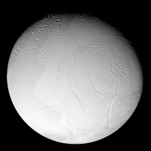
Approaching Enceladus
The images comprising this mosaic view were taken with NASA/ESA/ASI Cassini spacecraft narrow-angle camera at a distance of about 112 100 kilometres from Enceladus. The image scale is about 670 metres per pixel.
The south polar region (seen here at the lower right) has a distinctive tectonic structure that sets it apart from the rest of the satellite. Its outer boundary is marked by a series of pronounced tectonic 'gashes' that form a hoop-like boundary, near 60 degrees south latitude. In this image, this fault zone forms the transition region from the presumably older, cratered terrain in the north to the younger, nearly crater-free region in the south.
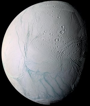
This false-colour view is a composite of individual frames obtained using filters sensitive to ultraviolet (centred at 338 nanometres), green (centred at 568 nanometres) and infrared light (centred at 752 nanometres). The view has been enhanced to accentuate subtle colour differences and fine-scale surface features.