About ESA
The European Space Agency (ESA) is Europe’s gateway to space. Its mission is to shape the development of Europe’s space capability and ensure that investment in space continues to deliver benefits to the citizens of Europe and the world.
Highlights


Latest


Space in Member States
Find out more about space activities in our 23 Member States, and understand how ESA works together with their national agencies, institutions and organisations.
 Germany
 Austria
 Belgium
 Denmark
 Spain
Spain
 Estonia
 Finland
 France
 Greece
 Hungary
 Ireland
 Italy
Italy
 Luxembourg
 Norway
 The Netherlands
 Poland
 Portugal
 Czechia
 Romania
 United Kingdom
 Slovenia
 Sweden
 Switzerland
Science & Exploration
Exploring our Solar System and unlocking the secrets of the Universe
Go to topicAstronauts


Latest


Enabling & Support
Making space accessible and developing the technologies for the future
Go to topicLatest


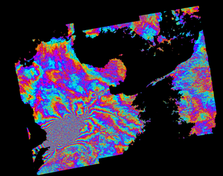
Two months of pit movement compared
International engineering firm AMEC is working with ESA's Earth Observation Market Development (EOMD) Programme on the application of satellite data to better monitor ground subsidence linked to mining activity. The satellite-derived images here compare slant range deformation occurring around the pit of Rio Tinto's Palabora mine in South Africa across two months. The first image covers 22 July to 15 August 2004, the second image covers 15 August to 8 September. Note a decrease in deformation in the second image. For legend see the image above. The results are based on Synthetic Aperture Radar (SAR) Interferometry (InSAR) results, overlaid on a Quickbird high-resolution optical image. The area enclosed in blue exhibits fast motion, the area enclosed in green exhibits slow motion. Slant deformation provided by Vexcel; the Quickbird image provided by Infoterra Ltd, copyright Digital Globe Inc 2004, data courtesy of Eurimage.