About ESA
The European Space Agency (ESA) is Europe’s gateway to space. Its mission is to shape the development of Europe’s space capability and ensure that investment in space continues to deliver benefits to the citizens of Europe and the world.
Highlights


Latest


Space in Member States
Find out more about space activities in our 23 Member States, and understand how ESA works together with their national agencies, institutions and organisations.
 Germany
 Austria
 Belgium
 Denmark
 Spain
Spain
 Estonia
 Finland
 France
 Greece
 Hungary
 Ireland
 Italy
Italy
 Luxembourg
 Norway
 The Netherlands
 Poland
 Portugal
 Czechia
 Romania
 United Kingdom
 Slovenia
 Sweden
 Switzerland
Science & Exploration
Exploring our Solar System and unlocking the secrets of the Universe
Go to topicAstronauts


Latest


Enabling & Support
Making space accessible and developing the technologies for the future
Go to topicLatest


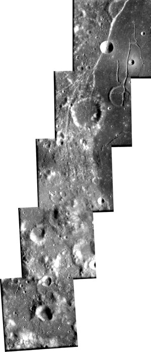
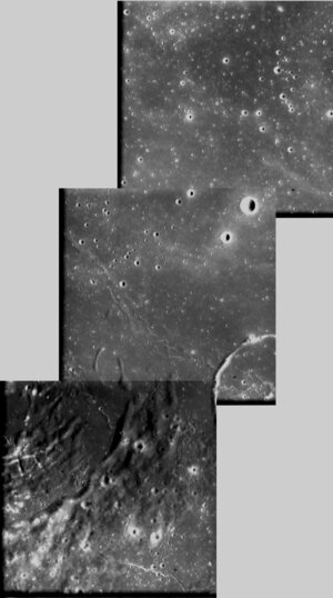
Highlands and 'mare' seen by SMART-1
These two images, taken by the advanced Moon Imaging Experiment (AMIE) on board ESA’s SMART-1 spacecraft, show the difference between lunar highlands (left) and a ‘mare’ area (right) from close by. Highlands present a very irregular topography and many craters, while the mare area is comparatively flat and shows a much smaller number of craters.
The first image, showing highlands, was obtained by AMIE on 22 January 2006, from a distance of about 1112 kilometres from the surface, with a ground resolution of 100 metres per pixel. The imaged area is centred at a latitude of 26º South and at a longitude of 157º West.
The second image, showing a mare, was taken on 10 January 2006, from a distance of about 1990 kilometres and with a ground resolution of 180 metres per pixel. The geographical coordinates of the area are 27.4º North latitude and 0.8º East.