About ESA
The European Space Agency (ESA) is Europe’s gateway to space. Its mission is to shape the development of Europe’s space capability and ensure that investment in space continues to deliver benefits to the citizens of Europe and the world.
Highlights


Latest


Space in Member States
Find out more about space activities in our 23 Member States, and understand how ESA works together with their national agencies, institutions and organisations.
 Germany
 Austria
 Belgium
 Denmark
 Spain
Spain
 Estonia
 Finland
 France
 Greece
 Hungary
 Ireland
 Italy
Italy
 Luxembourg
 Norway
 The Netherlands
 Poland
 Portugal
 Czechia
 Romania
 United Kingdom
 Slovenia
 Sweden
 Switzerland
Science & Exploration
Exploring our Solar System and unlocking the secrets of the Universe
Go to topicAstronauts


Latest


Enabling & Support
Making space accessible and developing the technologies for the future
Go to topicLatest


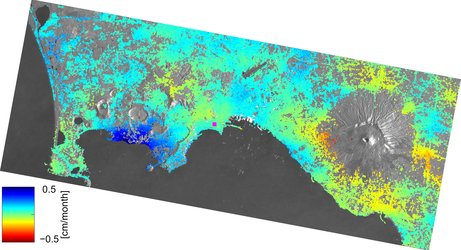
Deformation map for the Phlegrean Fields area
Deformation map for the Phlegrean Fields (Campi Flegrei) area obtained by using Envisat radar data. Ascending images (24) from February 2003 to April 2006 were employed to estimate the ground deformation map and time series. The deformation velocity was computed on the last 12 acquisitions, starting from January 2005 and shows an area of maximum deformation (exceeding 2 cm/year) localised in the centre of the Pozzuoli town, mainly in the harbour and surrounding zones (box A). The deformation also extends westward to the area surrounding Monte Nuovo (box B). The colours span from green (stable points) to red (maximum deformation upwards).