Accept all cookies Accept only essential cookies See our Cookie Notice

About ESA
The European Space Agency (ESA) is Europe’s gateway to space. Its mission is to shape the development of Europe’s space capability and ensure that investment in space continues to deliver benefits to the citizens of Europe and the world.
Highlights
ESA - United space in Europe
This is ESA ESA facts Member States & Cooperating States Funding Director General Top management For Member State Delegations European vision European Space Policy ESA & EU Space Councils Responsibility & Sustainability Annual Report Calendar of meetings Corporate newsEstablishments & sites
ESA Headquarters ESA ESTEC ESA ESOC ESA ESRIN ESA EAC ESA ESAC Europe's Spaceport ESA ESEC ESA ECSAT Brussels Office Washington OfficeWorking with ESA
Business with ESA ESA Commercialisation Gateway Law at ESA Careers Cyber resilience at ESA IT at ESA Newsroom Partnerships Merchandising Licence Education Open Space Innovation Platform Integrity and Reporting Administrative Tribunal Health and SafetyMore about ESA
History ESA Historical Archives Exhibitions Publications Art & Culture ESA Merchandise Kids Diversity ESA Brand Centre ESA ChampionsLatest
Space in Member States
Find out more about space activities in our 23 Member States, and understand how ESA works together with their national agencies, institutions and organisations.
Science & Exploration
Exploring our Solar System and unlocking the secrets of the Universe
Go to topicAstronauts
Missions
Juice Euclid Webb Solar Orbiter BepiColombo Gaia ExoMars Cheops Exoplanet missions More missionsActivities
International Space Station Orion service module Gateway Concordia Caves & Pangaea BenefitsLatest
Space Safety
Protecting life and infrastructure on Earth and in orbit
Go to topicAsteroids
Asteroids and Planetary Defence Asteroid danger explained Flyeye telescope: asteroid detection Hera mission: asteroid deflection Near-Earth Object Coordination CentreSpace junk
About space debris Space debris by the numbers Space Environment Report In space refuelling, refurbishing and removingSafety from space
Clean Space ecodesign Zero Debris Technologies Space for Earth Supporting Sustainable DevelopmentApplications
Using space to benefit citizens and meet future challenges on Earth
Go to topicObserving the Earth
Observing the Earth Future EO Copernicus Meteorology Space for our climate Satellite missionsCommercialisation
ESA Commercialisation Gateway Open Space Innovation Platform Business Incubation ESA Space SolutionsLatest
Enabling & Support
Making space accessible and developing the technologies for the future
Go to topicBuilding missions
Space Engineering and Technology Test centre Laboratories Concurrent Design Facility Preparing for the future Shaping the Future Discovery and Preparation Advanced Concepts TeamSpace transportation
Space Transportation Ariane Vega Space Rider Future space transportation Boost! Europe's Spaceport Launches from Europe's Spaceport from 2012Latest

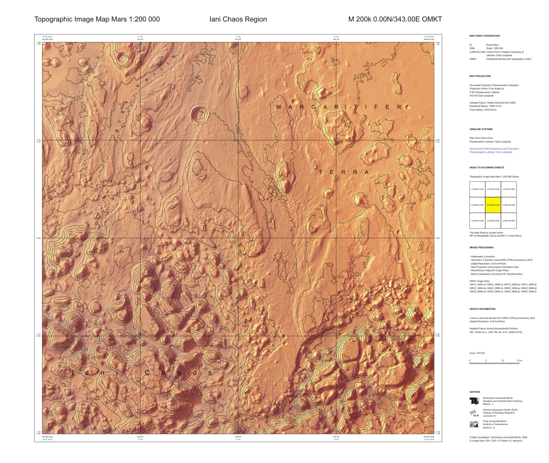
Topographic map of Mars at 1:200 000
Thank you for liking
You have already liked this page, you can only like it once!
A topographic map sheet of a part of the Iani Chaos region on Mars, based on image data obtained with the High Resolution Stereo Camera (HRSC) on board ESA's Mars Express. Such 'Topographic Image Map Mars 1:200 000' has been designed as an example of a possible standard map series for the HRSC experiment.
So far all map sheets are based on HRSC orthoimage mosaics and show contour lines derived from HRSC Digital Terrain Models (DTMs). Furthermore, they feature Martian topographic names (craters, mountains, valleys, etc.), cartographic grids, sheet names, individual designations, and all respective legend entries.
Should the outlined map series be realized, the planet Mars would be covered by 10 372 particular map sheets in equal-area map projections – 10 324 of them within the ±85° latitude zone in Sinusoidal Projection, supplemented by 48 polar sheets in Lambert Azimuthal Equal-area Projection. While each of the quadrangles spans 2° in latitude, longitudinal extents increase from 2° near the equator up to 360° toward the poles in order to keep the mapped area approximately constant. Therefore, the general layout of all maps appears very similar; each sheet features an overall width of 830 millimetres and a height of 700 millimetres.
The sheets of such a 'Topographic Image Map Mars 1:200 000' standard series as outlined here can be subdivided into sheets of quarters and sixteenths for systematic cartography in larger scale, 1:100 000 and 1:50 000 respectively. Within their mapped surfaces, the sheets differ in image resolution due to their different scales.
Although few effects of image compression are recognizable in the largest scale (such as the 1:50 000 map at, for instance, shadowed slopes), in general more texture details of the Martian surface become visible. A contour line equidistance of 250 metres is common for most of the sheets of the 1:200 000 topographic maps. In larger scales, a more subtle representation of the terrain topography is achieved by denser contour lines.
All map sheets have been generated using the cartographic software system 'Planetary Image Mapper' (PIMap), which has been developed at Technische Universität Berlin for cartographic presentation of HRSC data. Topographic map contents, graticules, frame lines, map titles as well as typical marginal elements can be generated and/or combined to the digital map sheet with PIMap.
The data were obtained on 5, 8 and 11 October 2004 (during orbits 0912, 0923 and 0934 of Mars Express) with best possible ground resolutions.
-
CREDIT
Map Compilation: Technische Universität Berlin, 2006; Image Data: ESA / DLR / FU Berlin (G. Neukum) -
LICENCE
ESA Standard Licence

Another topographic map of Mars at 1:200 000

Topographic map of Mars at 1:50 000

Topographic map of Mars at 1:100 000

Possible scales of topographic maps of Mars


 Germany
 Austria
 Belgium
 Denmark
 Spain
Spain
 Estonia
 Finland
 France
 Greece
 Hungary
 Ireland
 Italy
Italy
 Luxembourg
 Norway
 The Netherlands
 Poland
 Portugal
 Czechia
 Romania
 United Kingdom
 Slovenia
 Sweden
 Switzerland


