
About ESA
The European Space Agency (ESA) is Europe’s gateway to space. Its mission is to shape the development of Europe’s space capability and ensure that investment in space continues to deliver benefits to the citizens of Europe and the world.
Highlights


Latest


Space in Member States
Find out more about space activities in our 23 Member States, and understand how ESA works together with their national agencies, institutions and organisations.
 Germany
 Austria
 Belgium
 Denmark
 Spain
Spain
 Estonia
 Finland
 France
 Greece
 Hungary
 Ireland
 Italy
Italy
 Luxembourg
 Norway
 The Netherlands
 Poland
 Portugal
 Czechia
 Romania
 United Kingdom
 Slovenia
 Sweden
 Switzerland
Science & Exploration
Exploring our Solar System and unlocking the secrets of the Universe
Go to topicAstronauts


Latest


Enabling & Support
Making space accessible and developing the technologies for the future
Go to topicLatest


Clouds over Alpha Regio on Venus
This image of the Venusian south polar region was acquired on 24 September 2006 by the Ultraviolet, Visible and Near-Infrared Mapping Spectrometer (VIRTIS) on board ESA’s Venus Express, from a distance of about 65 000 kilometres from the planet’s surface.
The image, showing a complex cloud system, was taken on the night-side of Venus (04:00 local time), at a wavelength of 1.7 micron that allows viewing the deep atmospheric layers. The field of view covers an area located at approximately 20 degrees west longitude (diagonal top left to bottom right), spanning from the equator (at the horizon on the right) to 60 degrees southern latitude (top left corner of the image).
The grey-scale of the images is such that white signifies more transparency, therefore less clouds, while darker or blacker regions represent opacity, or thicker clouds.
The Alpha Regio area is at the bottom left of the image. This area is characterised by a series of troughs, ridges, and faults that are oriented in many directions, with surface features that can be up to 4 kilometres high. It is not yet clear if atmospheric turbulences may be induced by the rough topography below the clouds.

Close-up on cloud structures on Venus

Cloud structures in Venus atmosphere

Turbulences in Venus’s atmosphere
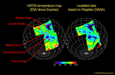
Temperature maps of Venus’ surface
