About ESA
The European Space Agency (ESA) is Europe’s gateway to space. Its mission is to shape the development of Europe’s space capability and ensure that investment in space continues to deliver benefits to the citizens of Europe and the world.
Highlights


Latest


Space in Member States
Find out more about space activities in our 23 Member States, and understand how ESA works together with their national agencies, institutions and organisations.
 Germany
 Austria
 Belgium
 Denmark
 Spain
Spain
 Estonia
 Finland
 France
 Greece
 Hungary
 Ireland
 Italy
Italy
 Luxembourg
 Norway
 The Netherlands
 Poland
 Portugal
 Czechia
 Romania
 United Kingdom
 Slovenia
 Sweden
 Switzerland
Science & Exploration
Exploring our Solar System and unlocking the secrets of the Universe
Go to topicAstronauts


Latest


Enabling & Support
Making space accessible and developing the technologies for the future
Go to topicLatest


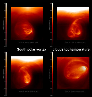
VIRTIS composite video of Venus’ south polar vortex
This composite video sequence was obtained by the Ultraviolet, Visible and Near-Infrared Mapping Spectrometer (VIRTIS) on board ESA’s Venus Express.
The single images were taken from 7 to 11 April 2007 over 5 different orbits. In each orbit the images were collected over a time span of 8 hours and were separated by about half an hour. The average distance from the planet was about 65 000 kilometres.
The latitude of the observed area spans 50 to 90 degrees South. The longitude spans about 20 to 150 degrees East.
The video shows details of the planet’s south pole in RGB colour. The data obtained at 1.7 microns is shown in blue, while those obtained at 3.8 microns is represented in red.
Using specific wavelengths (3.8 and 1.7 microns, respectively), the observations allowed the imaging of the day and night areas around the south pole simultaneously, at different depths (at about 65 kilometres and below the cloud deck, respectively) simultaneously. The intersection between the polar atmospheric structures seen at different wavelengths is visible well, due to the optical properties of the clouds.