About ESA
The European Space Agency (ESA) is Europe’s gateway to space. Its mission is to shape the development of Europe’s space capability and ensure that investment in space continues to deliver benefits to the citizens of Europe and the world.
Highlights


Latest


Space in Member States
Find out more about space activities in our 23 Member States, and understand how ESA works together with their national agencies, institutions and organisations.
 Germany
 Austria
 Belgium
 Denmark
 Spain
Spain
 Estonia
 Finland
 France
 Greece
 Hungary
 Ireland
 Italy
Italy
 Luxembourg
 Norway
 The Netherlands
 Poland
 Portugal
 Czechia
 Romania
 United Kingdom
 Slovenia
 Sweden
 Switzerland
Science & Exploration
Exploring our Solar System and unlocking the secrets of the Universe
Go to topicAstronauts


Latest


Enabling & Support
Making space accessible and developing the technologies for the future
Go to topicLatest


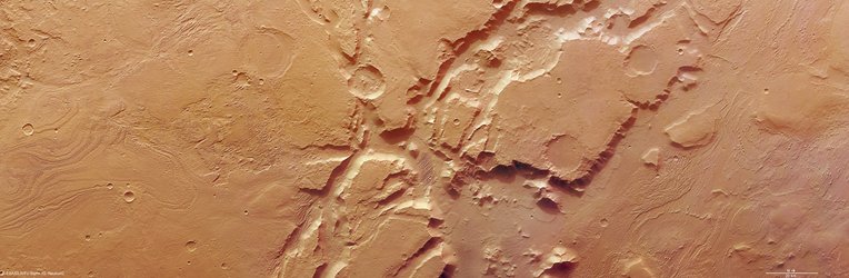
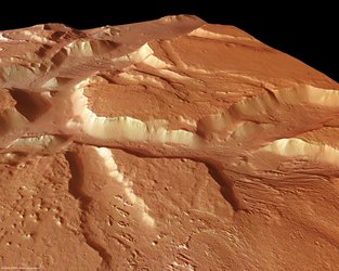
Aeolis Mensae South, anaglyph image
Mars Express’ High Resolution Stereo Camera (HRSC) has provided snapshots of the Aeolis Mensae region on the Red Planet.
The region, imaged on 26 and 29 March 2007, during Mars Express orbit number 4136 and 4247, is located at approximately 6° South and 145° East.
The morphology of the terrain, which lies close to the volcanic region of Elysium, is characterised by an extensive transition zone or the so-called ‘global crustal dichotomy boundary’ which separates the southern highlands and northern lowlands. It exhibits clod-shaped or lumpy relief separated by valleys and intermediated graben features, or elongated, trench-like structures, which are eroded landforms.
Aeolis Mensae is located at the border of the northern plains and the southern highlands, indicated by the transition zone. Between the highlands and the plains there is a large average difference in elevation, of about 3000 metres. The origin of this dichotomy is currently a subject of discussion.
This 3D (anaglyph) image was calculated by putting together data from the nadir channel and one of the stereo channels.