About ESA
The European Space Agency (ESA) is Europe’s gateway to space. Its mission is to shape the development of Europe’s space capability and ensure that investment in space continues to deliver benefits to the citizens of Europe and the world.
Highlights


Latest


Space in Member States
Find out more about space activities in our 23 Member States, and understand how ESA works together with their national agencies, institutions and organisations.
 Germany
 Austria
 Belgium
 Denmark
 Spain
Spain
 Estonia
 Finland
 France
 Greece
 Hungary
 Ireland
 Italy
Italy
 Luxembourg
 Norway
 The Netherlands
 Poland
 Portugal
 Czechia
 Romania
 United Kingdom
 Slovenia
 Sweden
 Switzerland
Science & Exploration
Exploring our Solar System and unlocking the secrets of the Universe
Go to topicAstronauts


Latest


Enabling & Support
Making space accessible and developing the technologies for the future
Go to topicLatest


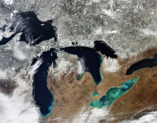
The Great Lakes of North America
This Envisat image highlights three of the five Great Lakes of North America. Lakes Huron (left) and Erie (bottom) are partially ice-covered following snow storms in Michigan and Cleveland, while Lake Ontario (right) is completely visible in blue.
The Great Lakes are said to be 'gifts of the glaciers' because of the way they were formed. About 100 000 years ago, the last major glacier called Laurentide (nearly 4 m thick) formed over most of Canada and part of the US.
As Laurentide formed, giant ice sheets flowed into the land carving out valleys and levelling mountains. Some 14 000 years ago warmer temperatures began to melt Laurentide. As it began to retreat, the resulting meltwater filled the huge holes left by the glaciers.
Covering a total area of 244 000 km² and containing about 23 000 km³ of water, together the Great Lakes form the largest connected area of fresh, surface water on Earth – roughly 18% of the world supply. The only place where more fresh water is contained is in the polar ice caps.
They have played an important role in North America's economic development by providing a transportation system between the agricultural and mining regions on the western shores with the market centres on the East Coast. The ability to ship materials such as coal, iron and ore also gave rise to the steel and automobile industries in the area.
The dark blue lines beneath Lake Ontario are some of the Finger Lakes in Upstate New York. These eleven lakes began as rivers running northward that were overrun by glaciers moving southward some 2 million years ago. Cayuga Lake (far right) is the longest, while Seneca Lake to its west is the deepest and largest in total area.
A part of the Appalachian Mountains is visible in the bottom left. The Appalachians stretch some 2400 km through eastern North America from the state of Alabama in the US to the province of Quebec in Canada.
This image was acquired by Envisat's Medium Resolution Imaging Spectrometer (MERIS) instrument on 22 February 2009, working in Full Resolution mode to provide a spatial resolution of 300 metres.