Accept all cookies Accept only essential cookies See our Cookie Notice

About ESA
The European Space Agency (ESA) is Europe’s gateway to space. Its mission is to shape the development of Europe’s space capability and ensure that investment in space continues to deliver benefits to the citizens of Europe and the world.
Highlights
ESA - United space in Europe
This is ESA ESA facts Member States & Cooperating States Funding Director General Top management For Member State Delegations European vision European Space Policy ESA & EU Space Councils Responsibility & Sustainability Annual Report Calendar of meetings Corporate newsEstablishments & sites
ESA Headquarters ESA ESTEC ESA ESOC ESA ESRIN ESA EAC ESA ESAC Europe's Spaceport ESA ESEC ESA ECSAT Brussels Office Washington OfficeWorking with ESA
Business with ESA ESA Commercialisation Gateway Law at ESA Careers Cyber resilience at ESA IT at ESA Newsroom Partnerships Merchandising Licence Education Open Space Innovation Platform Integrity and Reporting Administrative Tribunal Health and SafetyMore about ESA
History ESA Historical Archives Exhibitions Publications Art & Culture ESA Merchandise Kids Diversity ESA Brand CentreLatest
Space in Member States
Find out more about space activities in our 23 Member States, and understand how ESA works together with their national agencies, institutions and organisations.
Science & Exploration
Exploring our Solar System and unlocking the secrets of the Universe
Go to topicAstronauts
Missions
Juice Euclid Webb Solar Orbiter BepiColombo Gaia ExoMars Cheops Exoplanet missions More missionsActivities
International Space Station Orion service module Gateway Concordia Caves & Pangaea BenefitsLatest
Space Safety
Protecting life and infrastructure on Earth and in orbit
Go to topicAsteroids
Asteroids and Planetary Defence Asteroid danger explained Flyeye telescope: asteroid detection Hera mission: asteroid deflection Near-Earth Object Coordination CentreSpace junk
About space debris Space debris by the numbers Space Environment Report In space refuelling, refurbishing and removingSafety from space
Clean Space ecodesign Zero Debris Technologies Space for Earth Supporting Sustainable DevelopmentLatest
Applications
Using space to benefit citizens and meet future challenges on Earth
Go to topicObserving the Earth
Observing the Earth Future EO Copernicus Meteorology Space for our climate Satellite missionsCommercialisation
ESA Commercialisation Gateway Open Space Innovation Platform Business Incubation ESA Space SolutionsLatest
Enabling & Support
Making space accessible and developing the technologies for the future
Go to topicBuilding missions
Space Engineering and Technology Test centre Laboratories Concurrent Design Facility Preparing for the future Shaping the Future Discovery and Preparation Advanced Concepts TeamSpace transportation
Space Transportation Ariane Vega Space Rider Future space transportation Boost! Europe's Spaceport Launches from Europe's Spaceport from 2012Latest

Larsen B ice shelf collapse 2002
Thank you for liking
You have already liked this page, you can only like it once!
In 2002, within days of its 1 March 2002 launch, ESA's environmental satellite Envisat captured the disintegration of the Larsen-B ice shelf in Antarctica, surprising scientists because of the rapid rate at which the shelf broke apart.
Average temperatures in the Antarctic Peninsula have risen over the last 50 years by half a degree Celsius a decade and are having an impact on the ice shelves and glaciers. The ice retreat has been accelerating since 1992 and culminated in two collapse events: Larsen-A in January 1995 and Larsen-B in March 2002.
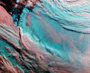
This poster compares images of the Larsen-B ice shelf taken during orbits 246 and 250, captured 18 March 2002, as seen by Envisat's Advanced Synthetic Aperture Radar (ASAR) instrument. The two images shown the disintegration of the 200-metre-thick Larsen-B ice shelf over several hours. Researchers estimate the ice shelf had been stable since the last ice age, 12 000 years ago.
The sections of Larsen-A, which disintegrated almost completely in January 1995, and Larsen-B, that broke away in 2002, were 200 to 350 metres thick.
After the collapse event in 2002, the outlet glaciers from the Antarctic Peninsula that previously nourished the ice shelf retreated many kilometres above the previous grounding line. Altogether about 250 square kilometres of grounded ice have been lost at the outlet glaciers of former Larsen-A and Larsen-B ice shelves.
The remoteness, darkness and cloudiness of Earth’s Polar Regions make them difficult to study. An instrument known as the Advanced Synthetic Aperture Radar (ASAR) allows Envisat to produce high-quality images of ice sheets because it is able to pierce through clouds and darkness.
Since the early 1990s, ESA has been able to provide near-continuous satellite data on the polar regions over long periods of time, which is essential for scientists to identify and analyse long-term climatic trends and changes. For instance, using radar altimeter data from ESA’s ERS-1 and ERS-2, scientists at NASA's Goddard Space Center mapped the height of the Antarctic and Greenland ice sheets and found there was a net loss of ice from the combined sheets between 1992 and 2002 and a corresponding rise in sea level.
Earth from Space: Larsen-B Ice Shelf on thin ice
Satellites shed light on global warming
Note: hi-res PDF download file is very large! Please be patient while file is transferred.
-
CREDIT
ESA -
LICENCE
ESA Standard Licence

Envisat image of the Larsen-B Ice Shelf

The Larsen-B Ice Shelf captured by Envisat

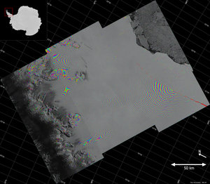
Larsen-C crack interferogram

Larsen Ice Shelf


 Germany
 Austria
 Belgium
 Denmark
 Spain
Spain
 Estonia
 Finland
 France
 Greece
 Hungary
 Ireland
 Italy
Italy
 Luxembourg
 Norway
 The Netherlands
 Poland
 Portugal
 Czechia
 Romania
 United Kingdom
 Slovenia
 Sweden
 Switzerland


