About ESA
The European Space Agency (ESA) is Europe’s gateway to space. Its mission is to shape the development of Europe’s space capability and ensure that investment in space continues to deliver benefits to the citizens of Europe and the world.
Highlights


Latest


Space in Member States
Find out more about space activities in our 23 Member States, and understand how ESA works together with their national agencies, institutions and organisations.
 Germany
 Austria
 Belgium
 Denmark
 Spain
Spain
 Estonia
 Finland
 France
 Greece
 Hungary
 Ireland
 Italy
Italy
 Luxembourg
 Norway
 The Netherlands
 Poland
 Portugal
 Czechia
 Romania
 United Kingdom
 Slovenia
 Sweden
 Switzerland
Science & Exploration
Exploring our Solar System and unlocking the secrets of the Universe
Go to topicAstronauts


Latest


Enabling & Support
Making space accessible and developing the technologies for the future
Go to topicLatest


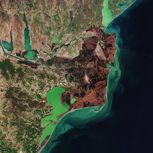
Colourful Camargue
This image from Japan’s ALOS satellite shows southern France and the divide of the Rhone River: the 'Grand Rhône' flows down the centre of the image while the 'Petit Rhône' is visible to the west.
This divide at the French city of Arles forms the Camargue delta region. The area is flat, with large lagoons and marshes. The land is largely used for agriculture, but a regional park protects this large and important wetland environment.
The research centre for Mediterranean wetlands, Tour du Valat, is located nearby in Arles.
As the home to hundreds of species of local and migratory birds, the Camargue is an important area for breeding and roosting, and is one of the few European habitats for the Greater Flamingo. The area also has its own breed of bull and horse.
In the upper right corner of the image, we can see the Alpilles mountains. The range is about 25 km long and reaches only 380 m in height. The ground is mostly dry and rocky. On the lower slopes, the land is cultivated with olive and almond trees.
The green area south of the mountains is a large nature reserve. Not only are the fauna and flora protected here, but the local tradition of sheep breeding is also preserved.
This image is a compilation of three passes by the Advanced Land Observation Satellite’s radar on 14 May 2008, 20 May 2010 and 5 July 2010.
Each is assigned a colour (red, green or blue) and combined to produce this representation. The colours reveal changes in the surface between the satellite’s passes.
This image is also featured in the Earth from Space video programme.