About ESA
The European Space Agency (ESA) is Europe’s gateway to space. Its mission is to shape the development of Europe’s space capability and ensure that investment in space continues to deliver benefits to the citizens of Europe and the world.
Highlights


Latest


Space in Member States
Find out more about space activities in our 23 Member States, and understand how ESA works together with their national agencies, institutions and organisations.
 Germany
 Austria
 Belgium
 Denmark
 Spain
Spain
 Estonia
 Finland
 France
 Greece
 Hungary
 Ireland
 Italy
Italy
 Luxembourg
 Norway
 The Netherlands
 Poland
 Portugal
 Czechia
 Romania
 United Kingdom
 Slovenia
 Sweden
 Switzerland
Science & Exploration
Exploring our Solar System and unlocking the secrets of the Universe
Go to topicAstronauts


Latest


Enabling & Support
Making space accessible and developing the technologies for the future
Go to topicLatest


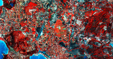
The French island of Corsica
This Envisat composite image shows the French island of Corsica, one of the largest islands in the Mediterranean Sea. Corsica is located just 90 km west of Italy, and 170 km south of France. Sardinia is just to the south across the Strait of Bonifacio, and we can see a couple of Sardinian islands along the bottom of the image. In the top right corner we can see the Italian island of Capraia.
This image was created by combining three Envisat radar acquisitions (3 January, 2 February and 2 April 2012) over the same area. The colours result from changes in the surface between acquisitions.
This image is featured on the Earth from Space video programme.