About ESA
The European Space Agency (ESA) is Europe’s gateway to space. Its mission is to shape the development of Europe’s space capability and ensure that investment in space continues to deliver benefits to the citizens of Europe and the world.
Highlights


Latest


Space in Member States
Find out more about space activities in our 23 Member States, and understand how ESA works together with their national agencies, institutions and organisations.
 Germany
 Austria
 Belgium
 Denmark
 Spain
Spain
 Estonia
 Finland
 France
 Greece
 Hungary
 Ireland
 Italy
Italy
 Luxembourg
 Norway
 The Netherlands
 Poland
 Portugal
 Czechia
 Romania
 United Kingdom
 Slovenia
 Sweden
 Switzerland
Science & Exploration
Exploring our Solar System and unlocking the secrets of the Universe
Go to topicAstronauts


Latest


Enabling & Support
Making space accessible and developing the technologies for the future
Go to topicLatest


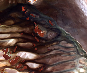
Flinders Ranges, South Australia
This image from Japan’s ALOS satellite shows part of the Flinders Ranges in South Australia, about 500 km north of Adelaide.
The area pictured is between Flinders Ranges National Park to the south, Vulkathunha-Gammon Ranges National Park to the north and Lake Frome due east (none of which is pictured).
The curving structures that dominate this image are part of a larger geosyncline – a subsiding linear trough in Earth’s crust – that includes the Flinders Ranges. The geosyncline consists of sedimentary rocks in a basin that were folded about 500 million years ago and have been eroded to the current landscape. In this image, the different colours show the different layers of rock.
Some of the oldest fossilised animal life have been found in parts of the Flinders Ranges.
Running up the middle of this image is a long, narrow gorge – typical of the ranges.
Along the right side of the image, the terrain is flat with a long, straight road running north–south. Numerous creeks appear like veins across the entire image.
The Flinders Ranges is one of Australia’s most seismically active regions, with numerous small earthquakes recorded every year.
Japan’s Advanced Land Observation Satellite captured this image on 3 January 2009. ALOS was supported as a Third Party Mission, which means that ESA used its multi-mission ground systems to acquire, process, distribute and archive data from the satellite to its user community.
This image is featured on the Earth from Space video programme.