About ESA
The European Space Agency (ESA) is Europe’s gateway to space. Its mission is to shape the development of Europe’s space capability and ensure that investment in space continues to deliver benefits to the citizens of Europe and the world.
Highlights


Latest


Space in Member States
Find out more about space activities in our 23 Member States, and understand how ESA works together with their national agencies, institutions and organisations.
 Germany
 Austria
 Belgium
 Denmark
 Spain
Spain
 Estonia
 Finland
 France
 Greece
 Hungary
 Ireland
 Italy
Italy
 Luxembourg
 Norway
 The Netherlands
 Poland
 Portugal
 Czechia
 Romania
 United Kingdom
 Slovenia
 Sweden
 Switzerland
Science & Exploration
Exploring our Solar System and unlocking the secrets of the Universe
Go to topicAstronauts


Latest


Enabling & Support
Making space accessible and developing the technologies for the future
Go to topicLatest


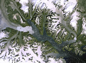
Southwestern coast of Greenland
On the southwestern coast of Greenland, multiple ice streams that drain the Greenland ice sheet are pictured in this satellite image.
Covering more than 2 000 000 sq km, Greenland is the world’s largest island and home to the second largest ice sheet after Antarctica.
Scientists used data from Earth-observing satellites have discovered that the rate of ice sheet melting is increasing. Between 1992 and 2012, Greenland was responsible for adding about 7 mm to the average global sea level. Many areas in Greenland – especially along the coast – are losing up to one metre of ice thickness per year.
Melting ice sheets caused by rising temperatures and the subsequent rising of sea levels is a devastating consequence of climate change, especially for low-lying coastal areas.
In addition, the increased influx of freshwater into oceans affects the salinity, which in turn impacts global ocean currents – a major player in the regulating of our climate.
In the lower part of the image, we can see icebergs speckling the waters of a fjord, with the mountainous Nuussuaq Peninsula visible along the bottom of the image.
This image was acquired by Landsat-8 satellite’s Operational Land Imager on 12 June 2013.