About ESA
The European Space Agency (ESA) is Europe’s gateway to space. Its mission is to shape the development of Europe’s space capability and ensure that investment in space continues to deliver benefits to the citizens of Europe and the world.
Highlights


Latest


Space in Member States
Find out more about space activities in our 23 Member States, and understand how ESA works together with their national agencies, institutions and organisations.
 Germany
 Austria
 Belgium
 Denmark
 Spain
Spain
 Estonia
 Finland
 France
 Greece
 Hungary
 Ireland
 Italy
Italy
 Luxembourg
 Norway
 The Netherlands
 Poland
 Portugal
 Czechia
 Romania
 United Kingdom
 Slovenia
 Sweden
 Switzerland
Science & Exploration
Exploring our Solar System and unlocking the secrets of the Universe
Go to topicAstronauts


Latest


Enabling & Support
Making space accessible and developing the technologies for the future
Go to topicLatest


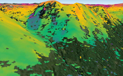
Norway relief
This interferogram of the northern coast of Norway combines two radar images acquired by Sentinel-1A on 11 August and 23 August 2014. Although Sentinel-1A is still being commissioned, this new result demonstrates how useful it will be to map the shape of the land and monitor ground movement. Synthetic aperture radar interferometry – or InSAR – is a technique where two or more satellite radar images acquired over the same area are combined to detect large-scale surface changes. Small changes on the ground cause changes in the radar signal phase and lead to rainbow-coloured fringes in the interferogram. In this case, the image mainly denotes differences in topography.
The Lyngen Alps are featured on the right where mountains up to 1800 m rise from the sea. Since the area is particularly prone to landslides, it is closely monitored. Large landslides could shift rock into the sea suddenly, which could potentially create tsunami-like waves. In 1810, such a wave destroyed a village, and history shows that this kind of natural disaster occurs a couple of times every 100 years in Norway. InSAR is already an important tool for nationwide rockslide hazard mapping by Norwegian authorities. The unprecedented coverage offered by Sentinel-1 will significantly increase the value of InSAR data for this purpose.