About ESA
The European Space Agency (ESA) is Europe’s gateway to space. Its mission is to shape the development of Europe’s space capability and ensure that investment in space continues to deliver benefits to the citizens of Europe and the world.
Highlights


Latest


Space in Member States
Find out more about space activities in our 23 Member States, and understand how ESA works together with their national agencies, institutions and organisations.
 Germany
 Austria
 Belgium
 Denmark
 Spain
Spain
 Estonia
 Finland
 France
 Greece
 Hungary
 Ireland
 Italy
Italy
 Luxembourg
 Norway
 The Netherlands
 Poland
 Portugal
 Czechia
 Romania
 United Kingdom
 Slovenia
 Sweden
 Switzerland
Science & Exploration
Exploring our Solar System and unlocking the secrets of the Universe
Go to topicAstronauts


Latest


Enabling & Support
Making space accessible and developing the technologies for the future
Go to topicLatest


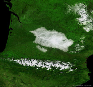
Lake Frome seen by Proba-V
ESA’s Proba-V minisatellite captures the rare sight of standing water in the arid south Australian outback.
Lake Frome, one of the whitest salt lakes in the southern hemisphere is visible to the right. Unusually, this 12 February image shows it filled with brackish water that has flowed down the creeks in the area, which are typically dry.
Covering most of this 100-m spatial resolution image are the ranges and gorges of Vulkathunha-Gammon Ranges National Park, haven to many rare and endangered plants and animals.
Launched in 2013, Proba-V is a miniaturised ESA satellite tasked with a full-scale mission: to map land cover and vegetation growth across the entire planet every two days.
Its main imager’s continent-spanning 2250 km swath collects light in the blue, red, near-infrared and mid-infrared wavebands – at 300 m spatial resolution and down to 100 m resolution in its central field of view.
VITO, the Flemish institute for technological research, processes and then distributes Proba-V data to users. VITO has a produced an online gallery highlighting some of the mission’s most striking images so far, including views of storms, fires and deforestation.