About ESA
The European Space Agency (ESA) is Europe’s gateway to space. Its mission is to shape the development of Europe’s space capability and ensure that investment in space continues to deliver benefits to the citizens of Europe and the world.
Highlights


Latest


Space in Member States
Find out more about space activities in our 23 Member States, and understand how ESA works together with their national agencies, institutions and organisations.
 Germany
 Austria
 Belgium
 Denmark
 Spain
Spain
 Estonia
 Finland
 France
 Greece
 Hungary
 Ireland
 Italy
Italy
 Luxembourg
 Norway
 The Netherlands
 Poland
 Portugal
 Czechia
 Romania
 United Kingdom
 Slovenia
 Sweden
 Switzerland
Science & Exploration
Exploring our Solar System and unlocking the secrets of the Universe
Go to topicAstronauts


Latest


Enabling & Support
Making space accessible and developing the technologies for the future
Go to topicLatest


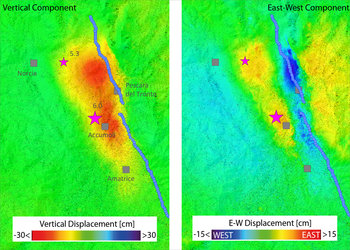
Nepal earthquake displacement
Based on data from the Sentinel-1A satellite, this image shows how and where the land uplifted and sank from the 7.8-magnitute earthquake that struck Nepal on 25 April 2015.
Near the boundary of the Indian and Eurasian tectonic plates, blue shows areas of uplift of up to 0.8 m towards the satellite (called ‘line of sight’) which could be caused by a vertical uplift of 1 m. The yellow area depicts areas of subsidence, a movement that often occurs as a counter movement to the uplift in subduction zones (where one plate dips below the other) during earthquakes. Additionally, a horizontal north–south shift of up to 2 m was detected.
This image was generated using data acquired by Sentinel-1A before and after the earthquake event.
This image was originally released by the DLR German Aerospace Center.