About ESA
The European Space Agency (ESA) is Europe’s gateway to space. Its mission is to shape the development of Europe’s space capability and ensure that investment in space continues to deliver benefits to the citizens of Europe and the world.
Highlights


Latest


Space in Member States
Find out more about space activities in our 23 Member States, and understand how ESA works together with their national agencies, institutions and organisations.
 Germany
 Austria
 Belgium
 Denmark
 Spain
Spain
 Estonia
 Finland
 France
 Greece
 Hungary
 Ireland
 Italy
Italy
 Luxembourg
 Norway
 The Netherlands
 Poland
 Portugal
 Czechia
 Romania
 United Kingdom
 Slovenia
 Sweden
 Switzerland
Science & Exploration
Exploring our Solar System and unlocking the secrets of the Universe
Go to topicAstronauts


Latest


Enabling & Support
Making space accessible and developing the technologies for the future
Go to topicLatest


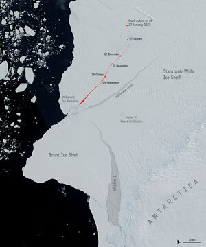
Ice cracked
One of the first images from Sentinel-3A’s Sea and Land Surface Temperature Radiometer (SLSTR) shows a long crack running through the ice shelf to the east of the centre part of the Antarctic Peninsula. The crack is about 2 km wide, but widens to 4 km or more in some places. There are also finer cracks and structures visible in the ice shelf. Structure in the cloud, cloud shadows and details of the land emerging from the ice can also be seen. The image was acquired on 3 March 2016 at 11:53 GMT with the instrument’s visible channel. As the SLSTR scans Earth’s surface, it senses visible light and infrared light (heat) in a number of different spectral channels. The thermal infrared channels will soon be working when the instrument has finished outgassing water vapour. This is necessary because the infrared channels must be cooled to operate properly. The SLSTR will measure global sea- and land-surface temperatures every day to an accuracy of better than 0.3ºC.